Login

Cornell’s Jane Doe sent a letter to faculty leaders saying she felt ‘unsupported’ by university president
Jane Doe said comments made by Cornell’s president ‘diminished’ her confidence in the university’s administration

© AP

Jane Doe said comments made by Cornell’s president ‘diminished’ her confidence in the university’s administration
© AP
Firefighters’ response took more than seven minutes due to the Norfolk Southern train

© Google Maps
Jenny Haynes disputed the official police account after reviewing an incident report that she said incorrectly listed her 5-foot-tall pet as a 6-foot-tall threat

© FOX4
Recent policy changes have shifted different kinds of costs on to low- and middle-income earners, while leaving the wealthy relatively unscathed

© Getty Images
Amy Acton’s estranged mother appears on GOP attack ad accusing her of lying about her childhood as a survivor of sexual abuse
© AP
Amy Acton’s estranged mother appears on GOP attack ad accusing her of lying about her childhood as a survivor of sexual abuse
© AP
The world’s richest man has reportedly poured in hundreds of millions of dollars to support Republican candidates in the midterms as Democrats gain ground in several red states

© Getty Images
‘I mean this is a five-alarm Trumpster fire, that’s what we’re talking about,” CNN Chief Data Analyst Harry Enten said

© CNN
The child is in ‘unbearable pain,’ New Orleans officials said

© New Orleans Fire Department
The U.S. military has successfully demonstrated a new lower-cost receiver that could form part of a future over-the-horizon (OTH) radar. The testing also raises the question of whether the High Frequency Active Auroral Research Program (HAARP) research site in Alaska, which the U.S. Air Force transferred away more than a decade ago, could be repurposed for operational use in this role. A new radar of this kind would help the United States plug critical gaps in surveillance coverage over the ever-more strategic Arctic region. Canada is notably already pursuing a multi-billion-dollar OTH radar project in cooperation with Australia for this exact purpose.
The U.S. military put out a press release yesterday regarding the testing of the newly developed receiver array, which occurred between September 7 and September 11. This was the culmination of a series of “Arctic air domain awareness” experiments conducted cooperatively by U.S. and Canadian authorities over the past three years.

The final round of experimentation last month “examined whether an existing high-frequency transmitter [HAARP], paired with a newly developed, low-cost [16-element high-frequency] receiver array, could detect aircraft beyond the coverage of current long-range radar sites,” according to the release. “The effort focused on improving awareness across a region where vast distances, harsh weather and limited infrastructure present challenges for air surveillance.”
“Researchers used the University of Alaska Fairbanks’ High Frequency Active Auroral Research Program [HAARP] facility and a receiver array in Cold Bay developed by MITRE to collect data on participating aircraft over the Gulf of Alaska and Bering Sea,” the release added. “MITRE also supported the effort throughout the three-year experiment series and designed and executed the field experiment in partnership with government, scientific, and operational participants.”
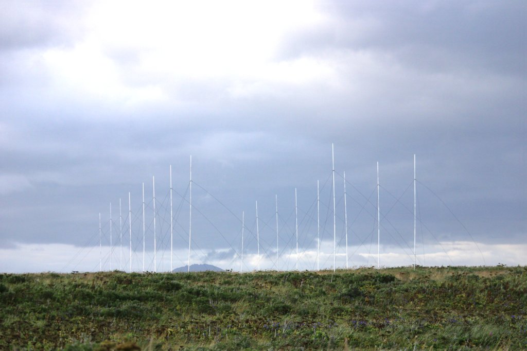
The remote HAARP site was built in the 1990s as part of a joint U.S. Air Force and U.S. Navy effort. The Defense Advanced Research Projects Agency (DARPA) was also involved. The central component of the 33-acre facility is an array of 180 crossed-dipole antennas, which can transmit up to 3.6 megawatts of radio frequency energy, according to the Air Force.
The primary purpose of HAARP was to provide U.S. government and independent researchers with a state-of-the-art facility to explore ionospheric phenomena. On the U.S. military side, work was focused on improving long-range surveillance and communications capabilities, including ways to communicate with submerged submarines. Over the years, HAARP has also been the subject of several entirely unsubstantiated conspiracy theories.
In 2014, the U.S. Air Force announced that it would shutter the HAARP site and dismantle it. However, the following year, the decision was instead made to transfer it to the University of Alaska Fairbanks, which has continued to operate it as a civilian research facility.
“During an experimental air domain awareness initiative, HAARP served as a high-power illuminator, transmitting signals toward the ionosphere to support the detection of airborne targets over Alaska’s maritime approaches,” according to the captions of several pictures that accompanied the release yesterday. “The experiment evaluated bistatic over-the-horizon detection methods to explore potential improvements in long-range surveillance and air domain awareness across Alaska’s maritime approaches.”
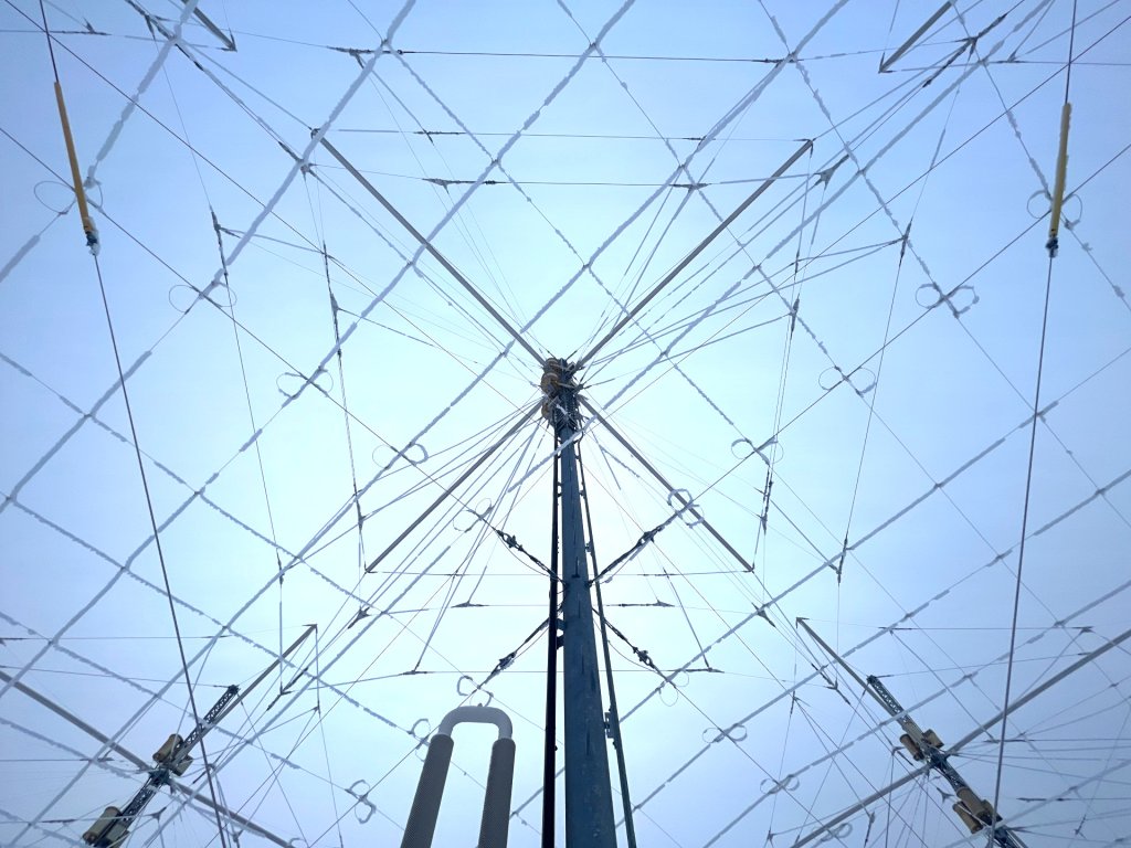
The most common types of OTH radars are so-called ‘skywave’ or ‘backscatter’ designs. They usually consist of two large and geographically separated arrays of antennas. The ‘illuminator’ array pumps out signals that are bounced off the ionosphere, the ionized layer of Earth’s upper atmosphere, at a specific angle so that they return to the ‘receiver’ array. Objects of interest (in the air and/or on the surface depending on the specific configuration) are detected in the process. As TWZ has previously written:
“Commonly, radars are limited by line of sight due to the curvature of the Earth in relation to the altitude they are operating at. OTHRs overcome this critical limitation, but with some major drawbacks.”
…
“While they offer much lower fidelity than many of their line-of-sight counterparts in most cases, they make up for it in huge range, hundreds of miles to thousands of miles (1,500 miles is common, for instance, for powerful military sky wave/backscatter OTHR systems) and a large coverage area. The sky wave type of OTHRs achieve this by bouncing their radio waves off the ionosphere to a coverage area where they hit targets and return the same way to the receiving station. The angle at which the radio waves hit the ionosphere dictates the range, and that angle is limited to a specific envelope or the waves won’t properly bounce back toward Earth. As such, placing the radar in the right place in relation to the targeted surveillance area or areas, to begin with, is key.”
In the testing last month, Air Force E-3 Sentry Airborne Warning and Control System (AWACS) radar planes, HC-130J Combat King II rescue aircraft, and KC-135 aerial refueling tankers “served as cooperative targets, providing known positions against which researchers could compare the experimental data,” according to the official release. “The team successfully completed testing, meeting or exceeding its test execution objectives. Initial results show the system was successfully able to achieve full skywave (beyond line of sight) detections of aircraft and correlation to truth flights. Thorough data analysis is ongoing.”


The release also says that the tests “explored how existing infrastructure and emerging technology could complement current surveillance capabilities.” This raises the possibility that the HAARP site, specifically, might be utilized as part of a new OTH radar. Whether or not this is actually under consideration is still unclear, and TWZ has reached out for more information.
Regardless, OTH radars have been experiencing something of a renaissance in recent years in the United States and elsewhere globally. Separate reports just in the past day or so have highlighted what appears to be significant progress on at least one part of a long-planned OTH radar in Russia’s Kaliningrad enclave.
Outside of Alaska, the U.S. military has been working to establish a Tactical Mobile Over-the-Horizon Radar (TACMOR) site in the South Pacific archipelago nation of Palau. The originally stated goal had been to finish work on this facility in 2026, but the project has faced legal challenges.
As already mentioned, OTH radars have also been part of U.S. plans to improve surveillance coverage in the Arctic. Like the recent testing in Alaska, there has been significant cooperation with Canada in this regard over the years, including through the U.S.-Canadian North American Aerospace Defense Command (NORAD).
Today, NORAD relies heavily on a network of ground-based radars called the North Warning System (NWS) to provide aerial surveillance coverage in the High North. The radars that make up the NWS are also all pointed northward, and none of them provide the kind of wide-area long-range coverage that an OTH design would offer.
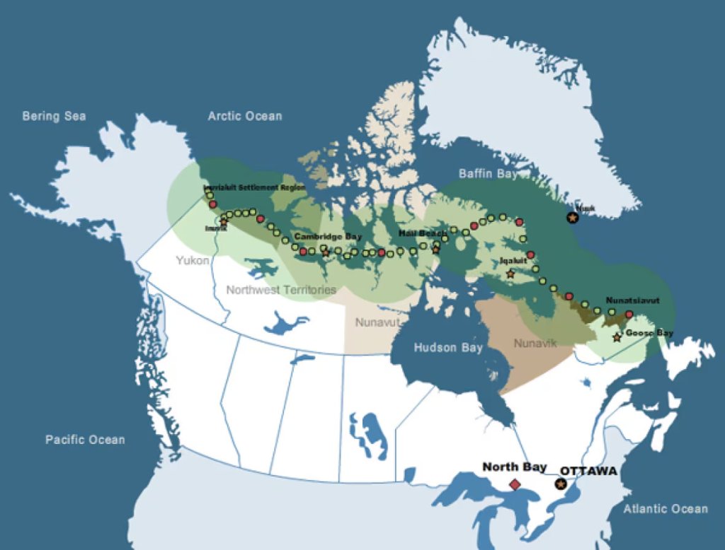
The NWS reflects a long-standing focus on monitoring for aerial threats heading across the North Pole toward North America, especially possible nuclear strikes from Russia (and the Soviet Union before it). However, new avenues for geostrategic competition in the Arctic with Russia, as well as China, over natural resources, from oil and natural gas to fish and other sealife, as well as trade routes have emerged in recent years amid receding ice and other impacts of global climate change. This, in turn, has only prompted growing demand for surveillance coverage.
“We need a layered sensing grid, from [the] seafloor to the space layer. And we have no choice. It has to be layered and deep, a defense in depth, from a sensing point of view,” Royal Canadian Air Force (RCAF) Maj. Gen. Chris McKenna, head of 1 Canadian Air Division and the Canadian NORAD Region, also said during a panel discussion at the Air & Space Forces Association’s (AFA) annual Warfare Symposium in 2025, at which TWZ was in attendance. “And I will say I suffer from an insufficiency of ISR [intelligence, surveillance, and reconnaissance] in the Arctic on a daily basis. And I am fighting for information.”
McKenna was responding at the time to a direct question about gaps in so-called “domain awareness” in and around the Arctic and how to address them.
“I think there’s an importance here of not just air domain, but also space domain, and having a sufficiency of ISR in the Arctic to actually build you the [domain awareness] picture,” he added. “I haven’t really touched on over-the-horizon radar, but I certainly can get into it. I think that’s a really important capability given the austerity of the Arctic and the need for it to cue other things.”
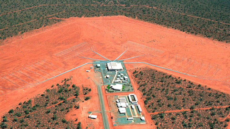
For its part, Canada is now building its own new Arctic Over The Horizon Radar (A-OTHR), at an estimated cost of more than $4 billion. In an announcement last year that caught many off guard, the Canadian government announced that it would be leveraging technology originally developed for Australia’s Jindalee Operational Radar Network (JORN) to support this development. It is also important to note here that relations between Canadian authorities and the Trump administration have been and continue to be heavily strained over a variety of issues, which has prompted broad concerns about future defense and security cooperation.
Back in the United States, OTH radar plans are also now tied in with the broader Golden Dome air and missile defense initiative. Golden Dome is seeking to establish new layers of defense around the U.S. homeland against a wide array of threat types, and puts major emphasis on new space-based sensor and interceptor capabilities. Expanded defensive architectures within the Earth’s atmosphere are also part of this plan.
“Adversaries are developing and building advanced nuclear and conventional delivery capabilities,” U.S. Army Lt. Gen. Joseph Jarrard, Vice Commander of the U.S. element of NORAD and Deputy Commander of U.S. Northern Command (NORTHCOM), warned at the annual Space & Missile Defense (SMD) Symposium in August. This includes “cruise, hypersonic, and ballistic missiles, as well as fractional orbital bombardment systems, or FOBS, to threaten not only Alaska and Hawaii, but the entire continent of the United States.”
Chinese hypersonic and other developments, in particular, enable new modes of attack that “can approach North America from the south, rather than the traditional northerly vector for which our legacy early warning radars were designed,” Jarrard continued. “The Chinese have also been building a conventionally-armed ICBM [intercontinental ballistic missile] equipped with hypersonic glide vehicles that can range [sic] targets throughout Alaska, providing Chinese leaders strike options against our homeland below the nuclear threshold.”
“Russia’s advanced missiles, like the nuclear-armed Avangard hypersonic glide vehicle, are designed to circumvent the ground-based radars used by NORAD and NORTHCOM to detect and characterize an inbound threat, and challenge the ability to provide threat warning and attack assessment,” he added.
New OTH radars positioned in Alaska and elsewhere in the Pacific will not be able to address all of these threat developments alone. At the same time, the recent testing leveraging the HAARP site is another step toward meeting demands for sorely needed expanded long-range radar coverage in the Arctic.
Contact the author: joe@twz.com
The post Alaska’s HAARP Site Now Being Used To Test New Air Force Over-The-Horizon Radar Tech appeared first on TWZ.

It was not immediately known whether the suspect was targeting the government building or what his motive might have been

© Copyright 2026 The Associated Press. All rights reserved
Major customers for the Max 10 include United Airlines, Delta Air Lines, American Airlines, and Ryanair
© Getty
‘You have to ask — what policy failure is Trump trying to distract Americans from this time?’ Governor Michelle Lujan Grisham said

© AFP via Getty Images
The Ukrainian President, Volodymyr Zelenskyy, is bitterly complaining that the country cannot intercept Russian ballistic missiles because Kyiv has not been receiving advance launch warnings from its partners for over a week.
On October 19, Zelenskyy wrote on platform X: “Another Russian ballistic missile attack came in several waves overnight, and once again, there was no early warning from our partners.”
Earlier, explaining the criticality of early missile warning, Zelenskyy said on October 13, “A Russian ballistic missile attack on Kyiv. Once again, no early warning from our partners… Our systems detected these missiles only when they were already virtually on approach to Kyiv. … And this is absolutely unjust: when they are destroying our energy infrastructure, and Ukraine is not even receiving early warnings about ballistic missile launches.”
Along with Patriot missile interceptors, Zelenskyy has described ‘missile early warning’ as absolutely vital to intercept Russian ballistic and cruise missiles.
“I spoke with Marco Rubio… First, ballistic missile interceptors, which are needed to protect lives. Second, early warning of Russian ballistic missile attacks, which is vital,” he said on October 20.
Zelenskyy has so far avoided blaming the US for failure to provide advance early warning of missiles; rather, he is blaming Ukrainian “partners” as a whole for this failure.
However, Ukraine’s European partners have absolutely no role in this, as they themselves are entirely dependent on the US for the space-based early missile-warning system.
Along with Starlink and Starshield, a space-based early missile-warning system is another critical area where Europe currently has no comparable system, and if Washington withdraws its support to Kyiv, Europe will be simply incapable of filling the gap.
While Europe has invested in ground-based radars and Airborne Warning and Control System (AWACS) aircraft, long-range radars that can track a missile in its mid- and terminal phases, Europe has no space-based early missile-warning system that can detect a missile launch in its boost phase and provide warnings to ground and airborne radars for tracking and intercepting the missiles.
This is critical for successfully intercepting ballistic and cruise missiles, as it gives ground-based and airborne radars more time to track and intercept them.
The US has a series of space-based satellites fitted with sensors that can detect, track, and identify missile launches from anywhere in the world, a Cold-War-era system that has been perfected and upgraded over the decades.
The US currently has six Lockheed Martin and Northrop Grumman satellites in geostationary orbit (GEO) around Earth to provide 24/7 global strategic missile-warning capability.
Launched between 2011 and 2022, these satellites are known as SBIRS (Space-Based Infrared System). The satellites carry high-power infrared sensors that monitor Earth’s surface nonstop to detect heat signatures from missile launches.

SBIRS satellites can scan large swaths of territory to detect missile activity and also focus on areas of interest for smaller-scale activities, including tactical ballistic missile launches.
These sensors are independently tasked, meaning the satellite can scan a wide territory while also focusing on a specific area of concern.
For instance, currently, the US SBIRS satellites would naturally scan Iran and Russia more than any other region.
During the missile’s initial boost phase, its exhaust plume releases intense heat. These intense heat signatures stand out in infrared sensors against the cooler Earth background.
Overhead Persistent Infrared (OPIR) sensors on satellites spot this signature within seconds of ignition, even through clouds or darkness, and provide ground-based stations and radars with the first warning of a missile launch.
These powerful sensors can detect any missile launch within seconds, from small, unsophisticated missiles such as the Iraqi Scuds, which were detected, tracked, and intercepted during the First Gulf War, to Russia’s large intercontinental ballistic missiles (ICBMs), and everything in between, such as the short-range ballistic missiles (SRBMs), submarine-launched ballistic missiles (SLBMs), and even cruise and hypersonic missiles.
These sensors can not only detect missile launches, but also identify them. Missile rocket motors produce exhaust gases at different temperatures based on their fuel, chemical composition, and other design features, helping these sensors identify distinct missile signatures.
However, infrared sensors on the six GEO satellites are not the US’s only space-based assets that help it detect missile launches in their boost phases.
The space segment of the SBIRS program also includes Highly Elliptical Orbit (HEO) sensors riding on host satellites and legacy Defense Support Program (DSP) satellites.
HEO sensors improve coverage of high-latitude and polar regions that are harder to monitor effectively from GEO alone.
The DSP program was launched in the 1970s, after the experimental Missile Defense Alarm System (MIDAS) of the 1960s proved the concept of detecting ICBM launches from space.
Under the DSP program, the US launched over 20 satellites with spinning IR sensors into geosynchronous orbit between 1970 and 2007.
DSP provided continuous strategic warning during the Cold War. It was this system that detected Iraqi Scud missiles during the First Gulf War.
The SBIRS program succeeded DSP, with significantly higher sensitivity, dual sensors, multi-spectral capability, better resolution, and improved ground processing.
Together, GEO, HEO, and DSP satellites provide 24/7 monitoring of Earth’s surface and can detect a missile launch from anywhere on Earth.
These satellites downlink data to ground stations (Air Force Space Command in Colorado), which analyze it to characterize the event, launch time and location, missile type, possible trajectory, and likely point of impact, then relay the information to NORAD, US Strategic Command, combatant commands, and missile defense systems.
This early missile warning is crucial to successful missile interception because it gives ground-based and airborne radars more time to track and intercept the missile, and Europe currently lacks a corresponding system.

SBIRS collects data and processes it at ground stations, then shares it with European allies through NATO’s Shared Early Warning System (SEWS).
This data is complemented by Europe’s ground-based and airborne radars, as well as by the US AN/FPS-132 Upgraded Early Warning Radar at RAF Fylingdales in the UK.
However, Europe has no comparable space-based early missile-warning system. It has some space situational awareness, but nothing equivalent to a persistent space-based infrared constellation for detecting missile launches.
Therefore, not only Ukraine but Europe itself depends on the US for early warning of ballistic or hypersonic missile threats.
Europe therefore cannot fill the gap if Washington decides not to share these missile-launch warnings with Kyiv.
Europe has pursued this capability for years; however, its programs have not progressed beyond the technology-demonstrator stage.
For instance, in 2009, France launched SPIRALE, a spaceborne early warning demonstrator program. It successfully collected infrared data on missile launches; however, the program ended in 2011 and France is yet to launch a full-scale follow-up program.
European countries also launched another technology demonstrator program, TWISTER, in 2019.
In October last year, France and Germany signed a Letter of Intent (LoI) to launch two complementary, interoperable geostationary (GEO) satellites with infrared sensors, under the JEWEL (Joint Early Warning for a European Lookout) program.
However, Europe currently has no sovereign, operational, space-based missile early-warning system.
Europe recognizes its vulnerability and has demonstrated its technological capability, but building a space-based, IR-sensor-equipped satellite constellation that provides nonstop coverage of every part of Earth’s surface would take at least a decade more.
Meanwhile, both Ukraine and Europe remain critically dependent on the US.
The post Europe “Blind in Space”: Why Only U.S. Can See Russian Missiles as Ukraine Begs For American Help? appeared first on EURASIAN TIMES.
Six in ten respondents expect the upcoming midterms to be administered fairly, with 65 percent expressing faith that votes will be counted accurately

© Getty
Two suspects are facing multiple charges in her death and sex assault

© Getty
‘I was dumbfounded. I thought I was reading it wrong’

© Getty/iStock
Health inspectors found milk crates being used as shelves, a torn door gasket on a food prep cooler, grease build-up on equipment, a leaking kitchen sink and improperly stored utensils

© Google Maps
The school district said that the student ‘allowed his emotions to override his judgment in the heat of the moment’

© Google Maps

© Invision