❌

Reading view

Des millions de données de l'ONU désormais accessibles sur une plateforme unique

Et si les millions de données produites par l’ONU étaient enfin accessibles en quelques clics, au même endroit ? C’est l’objectif du UN System Data Commons, une nouvelle plateforme lancée jeudi à New York par le Secrétaire général António Guterres pour faciliter l’accès aux statistiques et aux données publiques de l’ensemble du système des Nations Unies.

  •  

Casques bleus : le chef de l’ONU veut cesser de « maintenir une paix qui n’existe pas »

Confrontées à des guerres plus nombreuses et complexes, aux divisions des grandes puissances et à une contraction des moyens, les opérations de paix de l’ONU doivent changer de doctrine. António Guterres propose de recentrer les Casques bleus sur leur fonction première : préserver une paix négociée au préalable, plutôt que contenir indéfiniment des conflits que personne ne parvient à arrêter.

  •  

Ebola en RDC : en première ligne, les femmes paient un lourd tribut

En République démocratique du Congo (RDC), les femmes, qui représentent la majorité des personnes infectées par Ebola, sont particulièrement exposées au virus en raison de leur rôle essentiel dans les soins, aussi bien dans les établissements de santé qu’au sein des familles. ONU Femmes souligne également le risque de décès survenus dans les communautés et non recensés dans les statistiques officielles, notamment lorsque les personnes malades ne sont jamais prises en charge par le système de santé.

  •  

German Forces Surge Onto Baltic Island In First-Of-Its-Kind NATO Drill

Swedish and German forces are conducting what appears to be the first joint rehearsal of their rapid-reinforcement plans for the Baltic island of Gotland. The exercise is another step in Sweden’s defense planning for an island whose position in the middle of the Baltic gives it an outsized strategic importance for controlling access, protecting the Baltic states, and maintaining NATO’s freedom of movement in a region where Russian military activity remains a persistent concern.

Silver Wotan 2026 / Weiterer Text über ots und www.presseportal.de/nr/179237 / Die Verwendung dieses Bildes für redaktionelle Zwecke ist unter Beachtung aller mitgeteilten Nutzungsbedingungen zulässig und dann auch honorarfrei. Veröffentlichung ausschließlich mit Bildrechte-Hinweis.
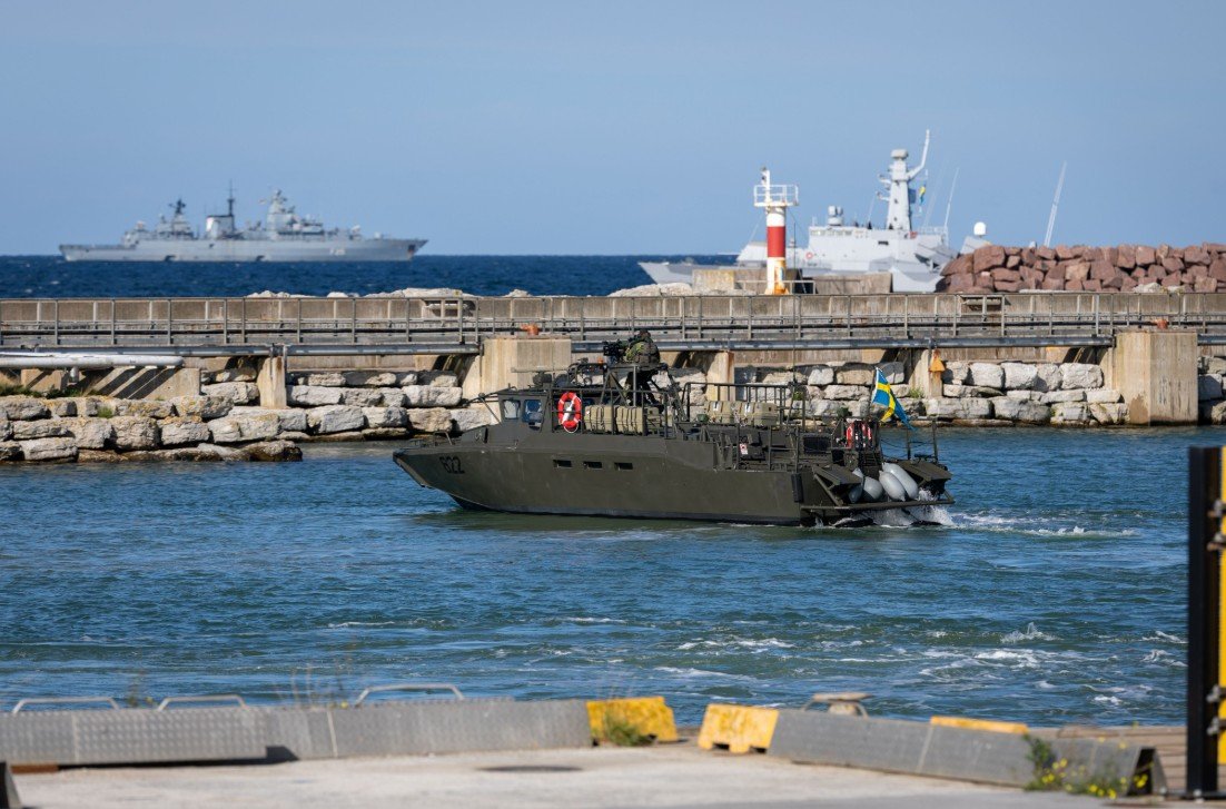
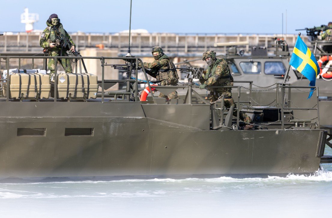
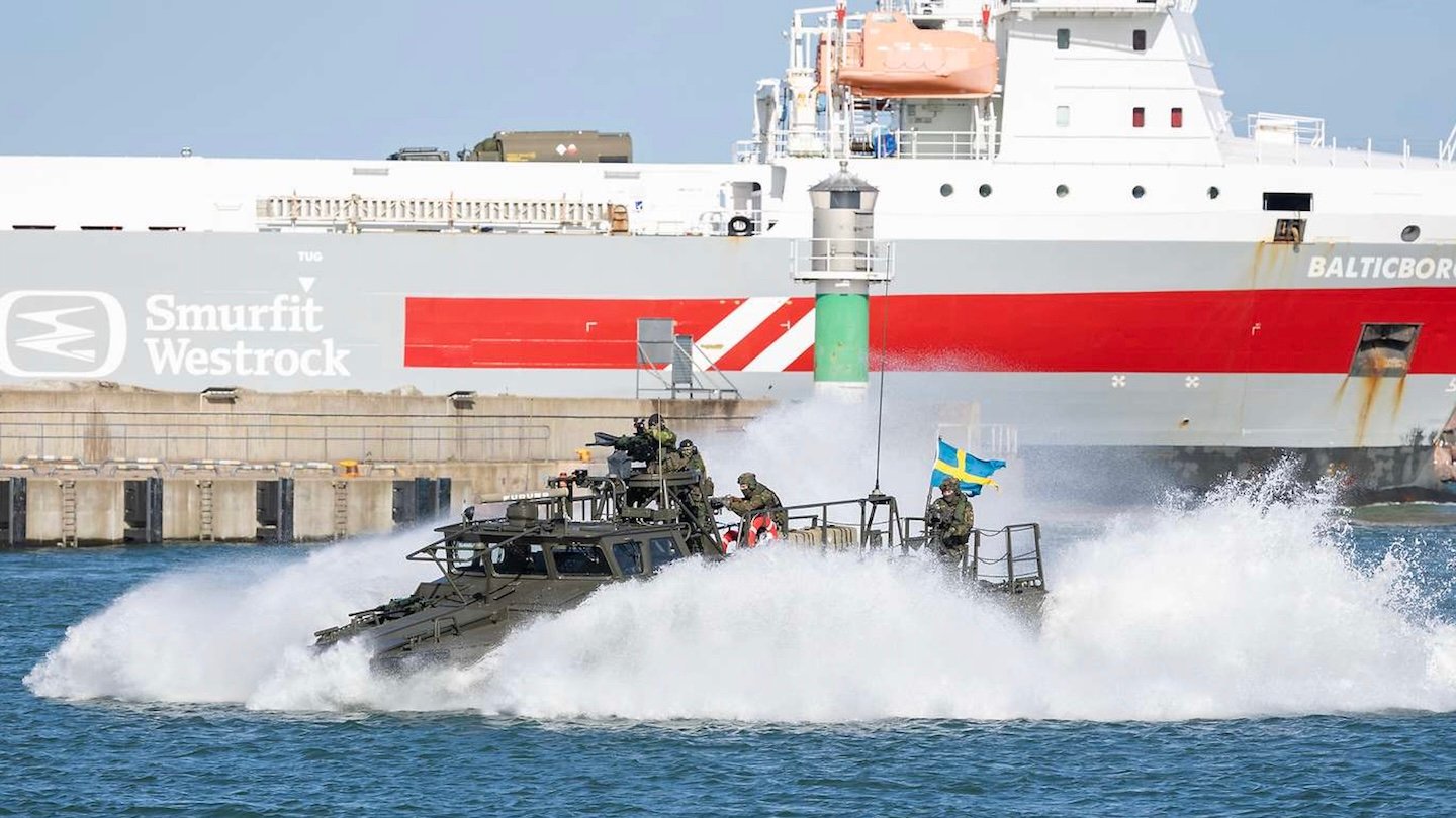
German and Swedish warships stand offshore while a Swedish CB90 fast assault craft operates in the harbor at Visby. Bundeswehr/Marc Tessensohn

The exercise, Silver Wotan 2026, running between September 14-23, brings together Swedish and German forces across the land, maritime, and air domains. The scenario is built around a Swedish request for allied assistance, with German forces moving personnel and equipment across the Baltic before integrating with Swedish units already defending the island. The operation is testing the entire process of getting allied combat power to Gotland, protecting it during the movement to Visby, and rapidly incorporating it into the island’s existing defensive network.

A video shows troops coming ashore on Swedish CB90 fast assault craft, a type that German soldiers are also trained to operate:

A rapid deployment of German and Swedish forces to Gotland island is being carried out today. Units from 🇸🇪 and 🇩🇪 are rehearsing the swift reinforcement of the strategic island in order to ensure the security of the Baltic Sea.#SilverWotan#NATO pic.twitter.com/A0r3LF8XUP

— Försvarsmakten (@Forsvarsmakten) September 18, 2026

The strategic importance of Gotland has grown considerably following Sweden’s accession to NATO in March 2024, which was a direct response to the full-scale Russian invasion of Ukraine.

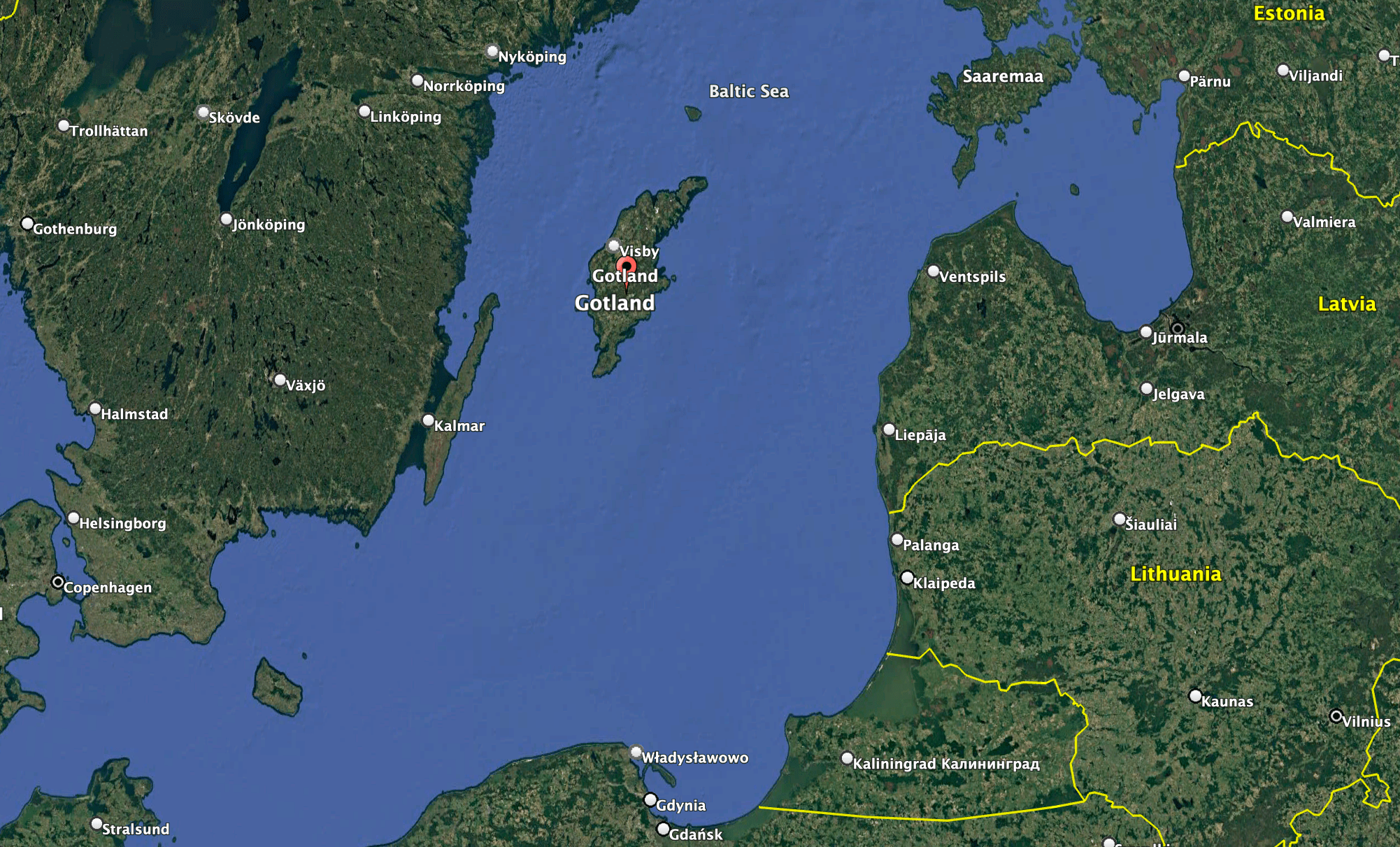
Located approximately halfway between mainland Sweden and the Baltic states, the island occupies a central position in the Baltic Sea, close to the maritime approaches to the Gulf of Finland and within reach of the Russian exclave of Kaliningrad. Its location gives forces operating from Gotland a potentially significant position from which to conduct surveillance, air defense, and maritime operations, while also making the island an important part of the wider network connecting NATO’s northern and eastern members.

The location of Gotland within the Baltic region. Google Earth

At the same time, Gotland sits within an extremely complex littoral environment, where shallow waters, islands, narrow maritime approaches, and the proximity of multiple states can make both offensive operations and defensive planning more difficult. The region has also been shaped by longstanding Swedish concerns about Russian clandestine activity, including intelligence gathering and other forms of covert or deniable activity. The complexity of the Baltic operating environment can make such activities harder to detect and attribute, adding another layer of uncertainty alongside the more conventional military challenges facing the region.

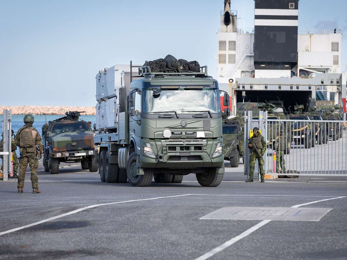
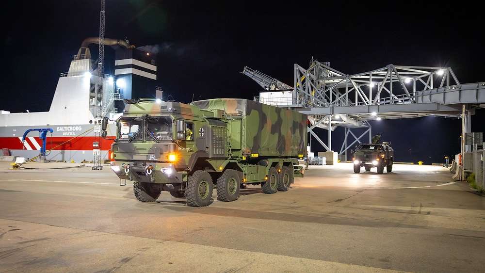
The unloading operation in Visby. The vehicles seen here were transported by sea from Karlskrona to the Swedish mainland. Bundeswehr/Marc Tessensohn

Geography has long made Gotland important to Swedish defense planning, but its significance has taken on a broader dimension since Sweden joined the alliance. NATO has described the island as strategically important to its freedom of maneuver in the Baltic, while Swedish officials have highlighted its potential role as a hub for military operations and logistics in the region.

The current exercise is designed around the practical difficulties of reinforcing such a position.

Military equipment is being transported by sea to Visby, Gotland’s principal port, including by commercial ferry. In Visby, Swedish and German personnel are securing the harbor and conducting the reception of the arriving force. Among the equipment being moved are air defense systems, while Swedish forces are also operating coastal defense systems armed with anti-ship missiles.

German Army vehicles roll into Visby during Silver Wotan. Bundeswehr/Marc Tessensohn

Meanwhile, publicly available flight-tracking data showed German Luftwaffe transport aircraft, including at least one Airbus A400M airlifter, apparently involved in the effort. The commercial airport at Visby has long also been used for military activities related to Gotland and the wider Baltic region.

”A rapid deployment of German and Swedish forces to Gotland island is being carried out today” https://t.co/z6oLs1LCT4 pic.twitter.com/n18MdST6r1

— Jamming (@balticjam) September 18, 2026

The movement is supported by Swedish and German naval forces and other aircraft, creating a scenario in which the maritime transit, protection of the port, air operations, and subsequent movement of troops and equipment ashore all form part of the same military problem. Once ashore, the arriving forces have to be moved into position and integrated with Swedish units already responsible for defending the island.

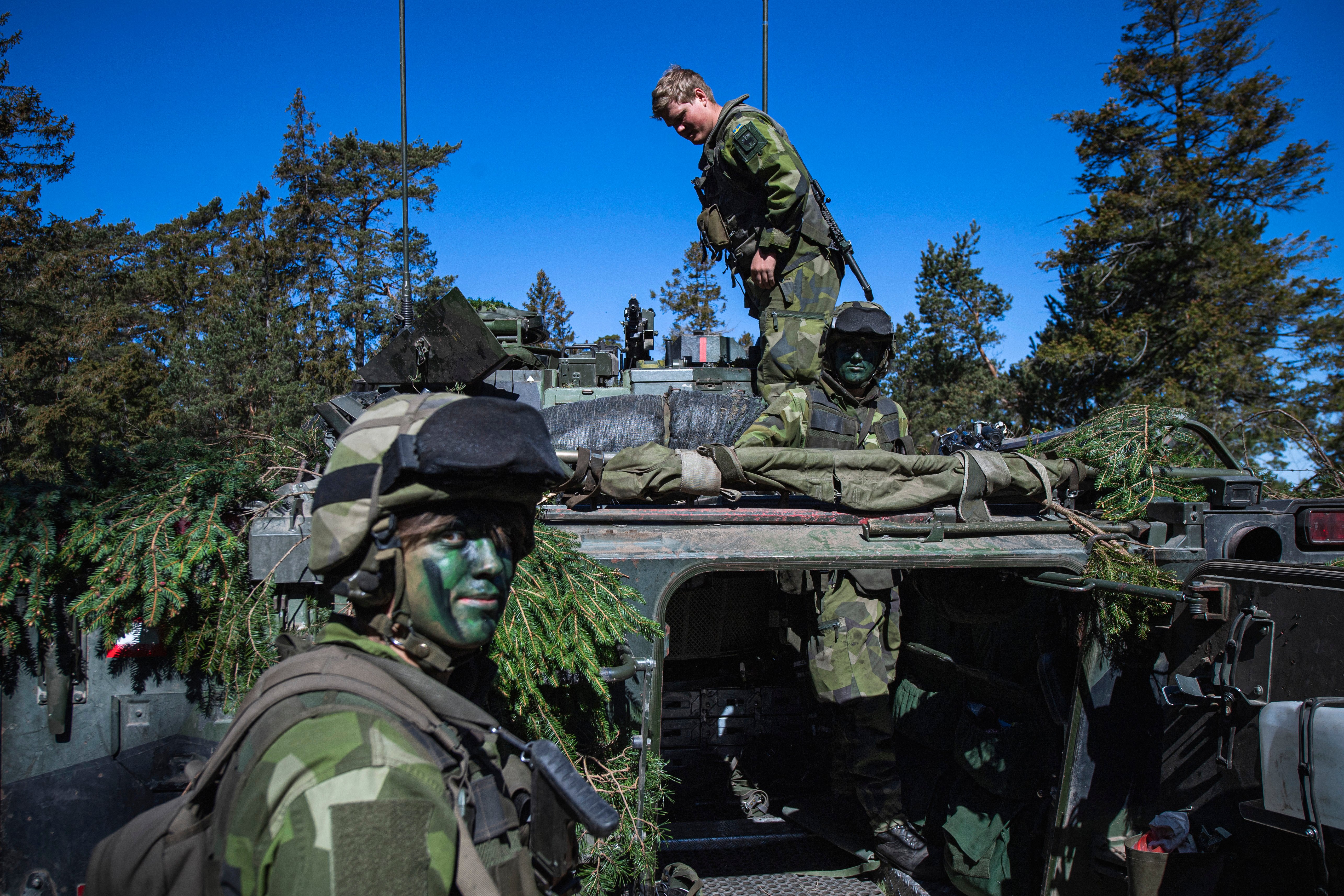
The Swedish Gotland Regiment, P 18, provides the core of the island’s permanent military presence. The regiment, Sweden’s youngest and smallest, has been rebuilding its capabilities since Sweden began expanding its military presence on Gotland. Its forces form the basis of the ground-defense structure into which allied reinforcements would be incorporated.

Soldiers of the P18 Gotland Regiment of the Swedish Army camouflage an armoured vehicle during a field exercise near Visby on the Swedish island of Gotland on May 17, 2022. Finland and Sweden are expected to announce this week whether to apply to join NATO following Russia's Ukraine invasion, in what would be a stunning reversal of decades-long non-alignment policies. On Sweden's strategically-located Baltic Sea island of Gotland, Home Guard troops were last week called in for a special month-long training exercise, coinciding with annual military exercises taking place across Finland and Sweden next week. (Photo by Jonathan NACKSTRAND / AFP) (Photo by JONATHAN NACKSTRAND/AFP via Getty Images)
Soldiers of the Gotland Regiment of the Swedish Army camouflage an armoured vehicle during an earlier field exercise near Visby. Photo by Jonathan NACKSTRAND / AFP

Swedish coastal defense capabilities are another important element of the drill. Land-based anti-ship missiles provide the island with a means of threatening hostile surface vessels operating in the surrounding waters, giving the defense of Gotland a direct connection to the wider maritime battle for the Baltic. During Silver Wotan, Swedish and German forces are also conducting anti-surface warfare activities alongside the broader reinforcement operation.

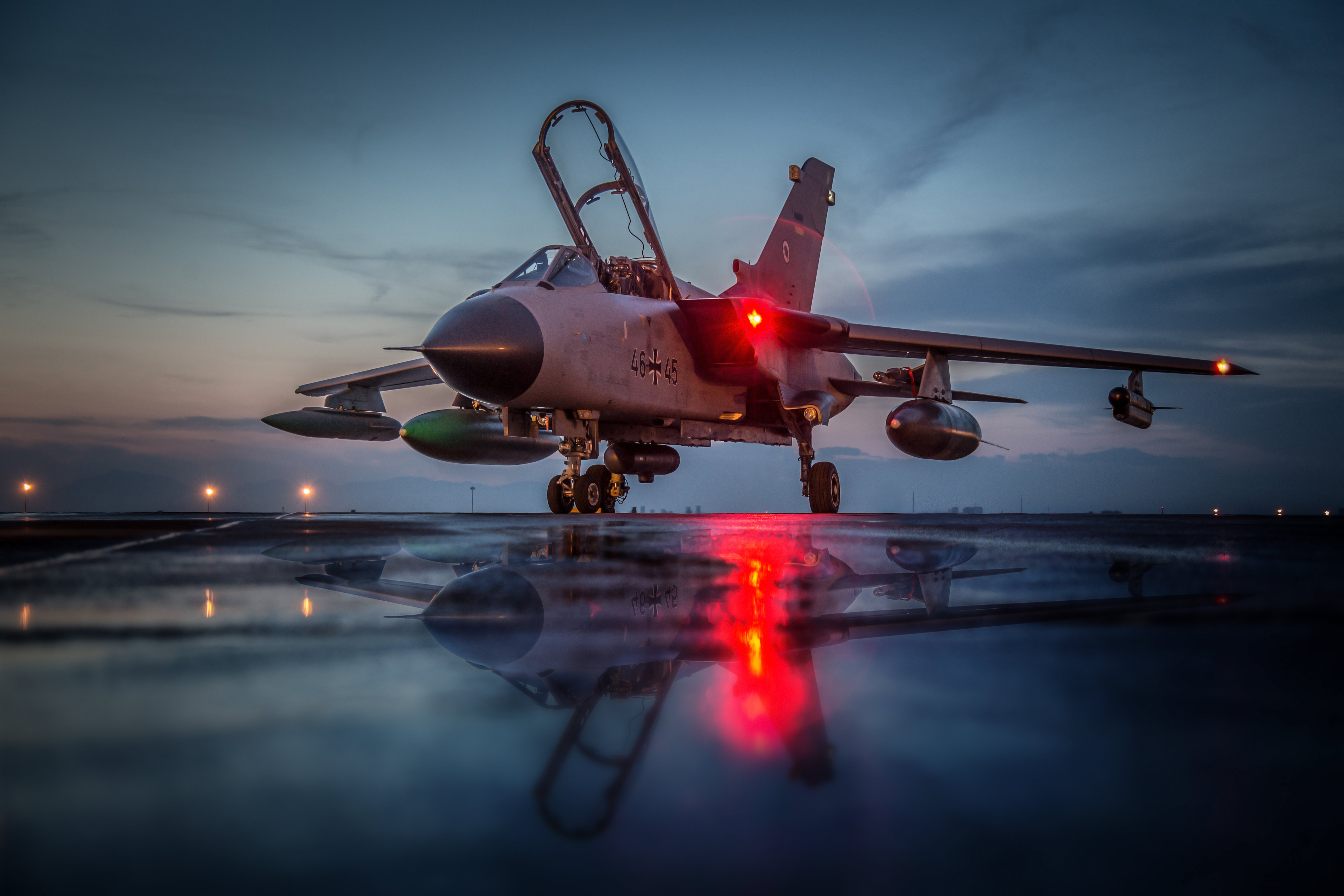
Germany is contributing more than 500 troops to the exercise, part of approximately 2,000 Bundeswehr personnel involved, including elements from the army, navy, and air force. The German Luftwaffe has deployed Panavia Tornado aircraft for surveillance, while German naval forces are participating in the maritime component, and German ground personnel are involved in the reinforcement and security activities on Gotland.

Piloten mit einer Nachtsichtbrille im Cockpit des Tornados 46+45 im Rahmen der Mission Counter Dash in Incirlik, Türkei, am 14.04.2016
Stock photo of a Luftwaffe Tornado ECR equipped for a reconaissance mission. Bundeswehr

The exercise scenario is particularly relevant against the backdrop of Russia’s continuing military presence in the Baltic region.

Russia maintains major military infrastructure in Kaliningrad, including naval, air, missile, and air defense capabilities, while the Russian Baltic Fleet operates from bases in the region. Kaliningrad’s position between Poland and Lithuania gives Moscow a significant military foothold inside the NATO area, while Russian forces and military infrastructure elsewhere along the Baltic add to the complexity of operating and reinforcing allied territory in the region.

The security environment around the Baltic has also deteriorated considerably since Russia’s full-scale invasion of Ukraine. NATO has increased its surveillance and military activity in the region, including the launch of Baltic Sentry in January 2025 following a series of incidents involving critical undersea infrastructure. The alliance has subsequently expanded efforts to monitor maritime activity and protect infrastructure and sea lines of communication.

A picture taken on February 4, 2025 shows a Helicopter 15 (HKP15) (L) on the flight deck of patrol ship HMS Carlskrona (P04) on open water near Karlskrona, Sweden, as part of the NATO Baltic Sea patrol mission, the Baltic Sentry, aimed to secure critical underwater infrastructure. The patrol ship HMS Carlskrona (P04) set off from the naval port in Karlskrona on February 4, 2025 to become part of NATO's Baltic Sentry operation as one of several Swedish ships that are part of Standing NATO Maritime Group One (SNMG1). This is the first time the ship has hoisted the NATO flag on board. The purpose of NATO's Baltic Sentry operation is to demonstrate presence and secure critical underwater infrastructure. (Photo by Johan NILSSON / TT NEWS AGENCY / AFP) / Sweden OUT (Photo by JOHAN NILSSON/TT NEWS AGENCY/AFP via Getty Images)
A Swedish Navy Helicopter 15 on the flight deck of patrol ship HMS Carlskrona as part of the NATO Baltic Sea patrol mission, Baltic Sentry, aimed to secure critical underwater infrastructure. Photo by Johan NILSSON / TT NEWS AGENCY / AFP

Swedish authorities have stressed that Silver Wotan was planned in advance and is not being conducted in response to a specific imminent Russian threat. The exercise nonetheless reflects the operational environment in which Swedish and NATO planners now have to consider the possibility that maritime and air movements across the Baltic could be monitored, disrupted, or contested.

The exercise also builds on a series of increasingly large Swedish-led activities designed to test the reception of allied forces on Swedish territory. During Aurora 26 earlier this year, more than 18,000 troops from 13 countries participated in operations across Sweden, including the deployment of allied forces to Gotland alongside the Gotland Regiment and Swedish Home Guard. NATO described that activity as an emergency deployment intended to test the reinforcement of the island.

A Dutch Boeing AH-64 Apache attack helicopter takes part in a combat display during a press day for the military exercise Aurora 26 at the Revingehed training field outside Lund in Skane, Southern Sweden on April 29, 2026. The exercise at Revingehed includes personnel from several NATO countires with the focus on lessons learned from the war in Ukraine including drones. (Photo by Johan NILSSON / various sources / AFP via Getty Images) / Sweden OUT
A Dutch AH-64 Apache attack helicopter takes part in Exercise Aurora 26 in southern Sweden on April 29, 2026. Photo by Johan NILSSON / various sources / AFP

Silver Wotan places a more concentrated emphasis on the Swedish-German relationship and on the movement of an allied force into the island’s existing defensive structure.

Germany’s participation is also consistent with its growing military role in the Baltic and along NATO’s northeastern flank. Berlin is already providing forces for NATO’s forward defense in Lithuania and has increasingly emphasized the ability to move German forces rapidly across northern Europe in support of allied operations.

For Sweden, meanwhile, Gotland has become one of the clearest examples of how NATO membership has changed the country’s defense planning. The island remains a Swedish responsibility, but its location means that what happens there has consequences well beyond Sweden’s territorial defense.

Silver Wotan 2026 / Weiterer Text über ots und www.presseportal.de/nr/179237 / Die Verwendung dieses Bildes für redaktionelle Zwecke ist unter Beachtung aller mitgeteilten Nutzungsbedingungen zulässig und dann auch honorarfrei. Veröffentlichung ausschließlich mit Bildrechte-Hinweis.
German and Swedish troops on a Swedish CB90 fast assault craft. Bundeswehr/Marc Tessensohn

A defended and adequately supplied Gotland provides NATO with a strategically positioned base for surveillance and defensive operations in the Baltic, while the ability to reinforce it demonstrates that the alliance can maintain access to the island even as the surrounding maritime and air environment becomes more contested.

The exercise comes as European allies are being forced to plan for a NATO in which the United States may provide less of the conventional military weight it has supplied for decades. The Pentagon is reviewing the size and posture of U.S. forces in Europe, including the forces and capabilities Washington would make available in a European crisis, while NATO’s top commander has said further U.S. troop withdrawals should be expected as European allies build up their own conventional capabilities.

Silver Wotan 2026 / Weiterer Text über ots und www.presseportal.de/nr/179237 / Die Verwendung dieses Bildes für redaktionelle Zwecke ist unter Beachtung aller mitgeteilten Nutzungsbedingungen zulässig und dann auch honorarfrei. Veröffentlichung ausschließlich mit Bildrechte-Hinweis.
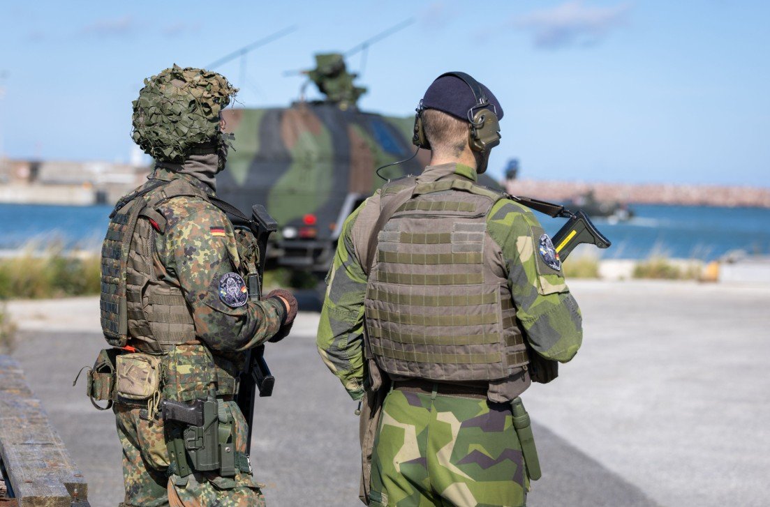
A German and a Swedish soldier involved in securing Visby during Silver Wotan 2026. Bundeswehr/Marc Tessensohn

At the same time, the alliance now describes Russia as its most significant and direct security threat, citing military activity alongside airspace violations, sabotage, cyber operations, and other forms of hybrid pressure. There are also growing concerns that Russia could try something in the Baltics, while it continues to step up its gray-zone activities regardless. NATO officials have warned that Russia could rebuild enough military capacity to pose a more serious conventional challenge to the alliance before the end of the decade.

There are escalating warnings from Poland that Russia is preparing to widen its war against Ukraine, with "accidental" missile and drone strikes on NATO territory.

Such a move – Russia falsely claiming air strikes that hit NATO allies happened by accident – would be designed to…

— Deborah Haynes (@haynesdeborah) September 18, 2026

For Sweden and Germany, the Silver Wotan exercise is a practical test of how quickly European forces can reinforce and defend one of the Baltic’s most strategically important positions. As the security environment grows more contested and Europe prepares for a future in which U.S. forces may not be as readily available, the ability to move allied combat power across the region and integrate it into existing defenses is becoming an increasingly important part of NATO’s deterrence.

Contact the author: thomas@thewarzone.com

The post German Forces Surge Onto Baltic Island In First-Of-Its-Kind NATO Drill appeared first on TWZ.

  •  

Saudi Arabia just lost big in Yemen —  Will Trump intervene?

Ansar Allah’s Red Sea wins last week torched Saudi’s decade-long strategy in Yemen – and the tens of billions it poured into trying to hold one of the world’s most vital shipping chokepoints. Shireen Al-Adeimi, Yemeni-born anti-war activist and Michigan State University professor, joins Zoe Alexandra to unpack what the seizure of Mokha and control of the Bab al-Mandeb Strait means for a global economy already brought to its knees by record $6/gallon diesel prices.

With the Strait of Hormuz still slowed to a trickle by the US-Israeli war on Iran and Riyadh’s East-West pipeline offline, Al-Adeimi says it’s in the whole world’s interest to “push the Saudis to just end this war. Admit that you’ve lost, cut your losses, and move on.” She breaks down how Riyadh’s violation of the 2022 ceasefire capped a decade of failed Saudi and UAE intervention, and why it matters that Pakistan just refused, for the second time, to back the Saudis under the Mecca joint defense pact – leading Riyadh to claim Mecca is under attack in a desperate PR stunt to shore up support it’s been cut off from in the West.

“This is hugely significant for Yemen as part of its long fight to end foreign intervention in Yemen… A strong Yemen – an anti-imperialist Yemen, a Yemen that is not going to allow the Gulf countries to treat it any way they wish, or to have a puppet government there in Yemen as we had before — is an inconvenience to these oil-producing countries.”

Watch full episodes of BT Live, join breakthroughnews.org as a member today!

  •  

Una pequeña victoria frente a los mapas que sitúan al Norte Global en el centro y empequeñecen a África.

Read in English here

La semana pasada, el 4 de septiembre, la Asamblea General de las Naciones Unidas aprobó una propuesta africana para un nuevo mapa mundial, que muestra el tamaño real de los países en relación con los demás. Su objetivo es corregir la visión del mundo moldeada por el mapa mundial ampliamente utilizado basado en la proyección de Mercator, creada por Gerardus Mercator, un cartógrafo flamenco del siglo XVI. El problema con el mapa de Mercator es bien conocido; por ejemplo, muestra a la isla de Groenlandia con el mismo tamaño que el continente africano, ¡a pesar de que África es 14 veces más grande que Groenlandia! En pocas palabras, los mapas de Mercator exageran enormemente el norte del mundo —los Estados Unidos y Europa— mientras que reducen África y la mayor parte de Asia. Tampoco trata con benevolencia al resto del hemisferio sur. Sudamérica, que tiene casi tres veces el tamaño de Europa, parece comparable a esta en un mapa típico de Mercator.

Aunque no existe ninguna razón geográfica por la que el hemisferio sur deba ser más pequeño que el hemisferio norte, los cartógrafos lo hicieron significativamente más pequeño porque tenía muy poca masa continental más allá de los 40 grados y, por lo tanto, se recortó. Esto significó que, en la mayoría de los mapas de Mercator, debido a que los cartógrafos occidentales recortaron gran parte del hemisferio sur, el ecuador quedó significativamente desplazado hacia abajo. El doble efecto de comprimir las zonas ecuatoriales, donde se encuentra gran parte de África, y desplazar el ecuador hacia abajo hizo que el norte del mundo, particularmente Europa y América del Norte, parecieran mucho más grandes de lo que realmente son. Por lo general, en la mayoría de los mapas de Mercator, el hemisferio norte parece el doble del tamaño del hemisferio sur, aunque ambos hemisferios son idénticos en tamaño.

Cualquier mapa, ya sea de Mercator o de cualquier otra proyección, presenta el problema de que se puede ser fiel al tamaño o a la forma, pero no a ambos. Se trata de un problema fundamental que surge al proyectar una superficie tridimensional sobre una hoja de papel bidimensional. No hay forma de hacerlo sin distorsiones. Solo un globo terráqueo puede representar fielmente la Tierra tridimensional. Pero entonces, ¿qué hacemos cuando queremos reproducir detalles geográficos para nuestros lectores en libros o artículos?

Las distorsiones evidentes de la proyección de Mercator y su enfoque eurocéntrico dieron lugar a varias alternativas, particularmente entre los cartógrafos de la izquierda amplia o progresista. Otros, especialmente en los Estados Unidos y Europa, se han opuesto a ella, argumentando que el tamaño no importa y que no les molesta que se les muestre mucho más grandes de lo que realmente son. Sin embargo, muchos discreparon e intentaron desarrollar proyecciones alternativas. La proyección de Gall-Peterson, que contó con el respaldo del gobierno socialdemócrata alemán de Willy Brandt, es una de esas proyecciones. La proyección de Hobo Dyer, que se encuentra en el dominio público global —lo que significa que cualquiera puede usarla sin pagar regalías—, es otra. Finalmente, las Naciones Unidas han puesto fin a las guerras de los mapas, con una victoria rotunda a favor de la moción presentada por las naciones africanas para utilizar mapas de área igual. La votación fue de 164 a favor de la moción, con los Estados Unidos como único voto en contra.

El objetivo del mapa de Mercator era facilitar la navegación de los barcos en mar abierto, donde ya no es posible orientarse reconociendo diversas características topológicas, como ríos, colinas, aldeas, pueblos, etc. En mar abierto, si identificamos nuestra ubicación en un mapa de Mercator y el destino al que deseamos llegar, podemos viajar en línea recta, tal como se muestra en el mapa. Conserva la dirección, lo que significa que, si trazamos un rumbo en un mapa de Mercator, podemos fijar nuestro rumbo según él. Es por eso que los países marítimos utilizaban proyecciones de Mercator para la navegación cuando contaban con pocos instrumentos, más allá de la brújula y el sextante, para determinar su ubicación con respecto a su destino.

Es importante señalar que la dirección que se muestra en el mapa no es la ruta más corta entre el punto de partida y el destino.

El camino más corto entre dos puntos en la superficie del globo terráqueo es el arco del gran círculo que va desde su ubicación hasta su destino. Una línea recta en un mapa bidimensional puede parecer la distancia más corta, pero no lo es, ya que no toma en cuenta la curvatura de la Tierra. En pocas palabras, el precio que pagamos por convertir una superficie curva en una plana y bidimensional es que distorsionamos la forma de la superficie. Estiramos ciertas áreas y encogemos otras. En una Tierra plana, la distancia más corta sería la que indica su brújula, pero no así en una esfera.

Anteriormente, los barcos utilizaban las estrellas y el sol del mediodía para estimar dónde se encontraban y hacia dónde debían dirigirse. Fijar un rumbo hacia su destino utilizando un mapa de Mercator y una brújula resultaba mucho más sencillo que tratar de adivinar dónde se encontraba en un océano desierto, sin puntos de referencia, y cambiar constantemente de rumbo en busca de una ruta más corta. La línea constante en el mapa se denominaba “línea de rumbo”, y seguirla ayudaba enormemente a los navegantes. Los mapas de Mercator eran populares en Europa, particularmente en Europa occidental, ya que, aparte de los árabes, eran las principales naciones marítimas.

Mientras que los árabes se enfocaban en el comercio, particularmente en el Océano Índico, los europeos occidentales se dedicaban no solo a la pesca, sino también, fuera de temporada, a la piratería, las incursiones y el saqueo de otras naciones. Los vikingos, importantes figuras románticas en Hollywood, eran particularmente brutales, ya que combinaban el saqueo con el comercio de esclavos. Por supuesto, como todos los piratas, una vez que se alcanza el poder, se puede convertir ese poder marítimo en conquista. Los hombres del norte, o nórdicos, conquistaron Francia y más tarde Inglaterra, y son conocidos por nosotros como normandos. No muy diferentes de las Compañías Holandesa y Británica de las Indias Orientales, que comenzaron con el comercio y la piratería y más tarde establecieron imperios coloniales.

No es de extrañar que los reinos marítimos de Europa occidental, para quienes la guerra, la pesca para alimentarse y la caza de focas, morsas, etc., con el fin de obtener grasa y pieles, constituían las principales fuentes de riqueza, se centraran mucho más en la navegación y la construcción naval. Esto significaba que los barcos construidos para el agitado Océano Atlántico contaban con ciertos avances de los que carecían los barcos árabes e indios, aunque la brújula, el astrolabio, los mapas astronómicos y otros instrumentos náuticos procedían todos de Asia.

Los barcos de Europa occidental contaban con cañones montados en cubierta, lo que les permitía disparar “andanadas”, es decir, disparar múltiples cañones simultáneamente, a diferencia de los cañones montados en la proa y la popa. Esa es una de las principales razones por las que un puñado de países de Europa occidental pudo aprovechar los océanos para, primero, hacerse con el comercio marítimo y, más tarde, construir sus imperios coloniales. A diferencia de los fuertes fijos, los barcos actuaban como fuertes flotantes, lo que proporcionaba a los europeos una movilidad en las guerras navales de la que carecían las fortificaciones terrestres estáticas.

Como muestra la monumental obra de Needham sobre la ciencia y la tecnología chinas, muchos avances náuticos en la construcción naval y la navegación procedían de China. Los siete viajes de los barcos de Zheng He en el siglo XV (1405-1443), que partieron de China, el sudeste asiático y la India, y recorrieron la costa árabe hasta África, demostraron que los chinos habían construido enormes barcos y una poderosa armada. En aquella época, se encontraban muy por delante de Europa y de los árabes, tanto en la construcción naval como en los buques de guerra. Las diferencias internas entre la aristocracia terrateniente y los comandantes navales condujeron a la destrucción de la armada y a la prohibición de construir cualquier buque de alta mar.

Aunque la India suministraba a los árabes la madera necesaria para la construcción naval y en algún momento contó con una poderosa armada, cedió el comercio de alta mar a los comerciantes árabes. Ni China, ni la India, ni los árabes consideraban que la armada tuviera importancia militar. Como dijo un emperador mogol: “Los océanos son para los comerciantes, no para nosotros, los guerreros”. Las divisiones de castas en la India también llevaron, en un momento dado, a prohibir a las castas superiores emprender viajes oceánicos. La travesía del Kala Pani, siempre prohibida por los brahmanes, no se respetó de manera estricta. La India experimentó una gran expansión marítima en el período budista, no a través de la guerra, sino mediante el comercio y la labor de proselitismo de los monjes budistas. Tras el resurgimiento del hinduismo en el sur, el tabú que prohibía a las castas superiores viajar a través de los océanos se aplicó de manera más estricta, dejando los océanos en manos de comerciantes y mercenarios. Por ejemplo, las principales flotas de los reyes indios – ya fuera el rey de Calicut, también conocido como Samundri o Zamorin, o Shivaji – dependían de comandantes navales y buques mercenarios, muchos de ellos al mando de árabes.

Como demuestra la historia, los mapas, el comercio marítimo y la guerra están íntimamente relacionados. Los viajes marítimos y las guerras navales confieren a los mapas una importancia estratégica. No es simplemente la ubicación de las fronteras de cada país lo que importa, sino también su visión estratégica del mundo. Podemos observar cómo esto se está manifestando actualmente en Bab el Mandeb y en el Golfo Pérsico. Un vistazo rápido a un mapa habría convencido a los líderes estadounidenses de que Irán cuenta con una clara ventaja estratégica en el Estrecho de Ormuz, al igual que los hutíes en el Mar Rojo y el paso hacia el Canal de Suez. Descuidar los océanos repite los errores que cometió Asia en una época diferente, errores de los que ha aprendido. Debemos tener esto presente también hoy en día.

Prabir Purkayastha es el editor fundador de Newsclick.in, una plataforma de medios digitales. Es activista en favor de la ciencia y del software libre.

Este artículo fue elaborado por Globetrotter.

  •  

White House Spiritual Advisor: Americans Must Pay 10% of Their Income To Israel To ‘Honor the Tithe’

Christian Americans owe 10% of their gross income to the state of Israel, according to Paula White, the televangelist who holds the title of White House spiritual advisor. “I believe that it’s so important to [...]

The post White House Spiritual Advisor: Americans Must Pay 10% of Their Income To Israel To ‘Honor the Tithe’ appeared first on The People's Voice.

  •  

Press-Freedom Coalition Calls for the Immediate Release of ICE-Detained Journalist Luis Galeano

On Friday, a coalition of 15 civil-society and press-freedom organizations demanded that U.S. Immigration and Customs Enforcement (ICE) release renowned Miami-based journalist Luis Galeano. The letter’s signers include Free Press, the Committee to Protect Journalists, the Freedom of the Press Foundation, the National Association of Hispanic Journalists, PEN America, Reporters Without Borders and the Society of Professional Journalists, among others.

Read the letter.

ICE detained Galeano on Sept. 14, 2026, while he was working as a rideshare driver to support his primary role as director of the news outlet Café con Voz. Galeano came to the United States in 2018 from Nicaragua. His reporting in Nicaragua had exposed the government’s significant human-rights abuses. Later, the Ortega-Murillo regime stripped nearly 100 journalists of their Nicaraguan citizenship as a penalty for covering the government’s totalitarian tactics.

Since arriving in the United States, Galeano has conducted Spanish-language reporting for communities throughout Florida. He has a Social Security number and a work permit, with a pending asylum case filed nearly seven years ago.

“The U.S. government’s targeting and detention of Galeano are a troubling escalation of attacks on journalists and media workers, particularly immigrant journalists, who consistently provide much-needed journalism and civic information for their communities,” the letter reads. “In the case of Galeano, there are severe dangers should the U.S. government seek to ignore his asylum case and move to deport him. The Department of Homeland Security (DHS) withdrew temporary protected status (TPS) for Nicaraguan immigrants starting in July 2025. That would mean any unfounded punitive actions taken against Galeano that might lead to his deportation could very well place him in dire circumstances upon return to Nicaragua, where he was a vocal leader in the press community advocating for human rights.”

Free Press Senior Counsel Nora Benavidez said:

“When the government arrests and detains a journalist and prevents them from doing their work, it sends a chilling message to other reporters and civilians considering speaking truth to power. It’s horrifying that Luis Galeano is now the latest in a long line of journalists who came to the United States to report on issues of the day and instead face deportation.

“To be clear: These cases aren’t just about cracking down on immigration. They are about cutting off community access to vital coverage and scaring reporters from holding those in power accountable. If our government can close off channels of exchange and the free flow of ideas, it is no more than a dictatorship. This coalition has joined together to urge for Luis Galeano’s release — and we will continue to advocate for press freedom as essential to our democracy and collective dignity.”

  •  

A small victory against the maps which center the global north and shrink Africa

Lee en español aquí

On September 4, the United Nations General Assembly adopted an African proposal for a new world map, which shows countries’ true size relative to one another. It aims to correct the view of the world shaped by the widely used world map based on the Mercator Projection, created by Gerardus Mercator, a 16th-century Flemish cartographer. The problem with the Mercator Map is well known; for example, it shows the island of Greenland as the same size as the African continent, even though Africa is 14 times the size of Greenland! Simply put, Mercator maps greatly exaggerate the global north – the US and Europe – while shrinking Africa and most of Asia. Nor does it treat the rest of the Southern Hemisphere kindly. South America, nearly three times the size of Europe, looks comparable to it on a typical Mercator map.

Though there is no geographical reason the Southern Hemisphere should be smaller than the Northern Hemisphere, mapmakers made it significantly smaller because it had very little landmass beyond 40 degrees and was therefore cropped out. This meant that on most Mercator maps, because Western mapmakers cropped out much of the Southern Hemisphere, the equator was significantly displaced downward. The double whammy of squeezing the equatorial areas, where much of Africa lies, and shifting the equator down made the global north, particularly Europe and North America, seem much larger than they actually are. Typically, on most Mercator maps, the Northern Hemisphere looks twice the size of the Southern Hemisphere, though the two hemispheres are identical in size.

Alternatives to the Mercator projection

Any map, whether Mercator or any other projection, has the problem that you can be true to either size or shape, but not both. The problem is a fundamental one of projecting a three-dimensional surface to a two-dimensional piece of paper. There is no way of doing this without distortions. Only a globe can truly represent the three-dimensional earth faithfully. But then what do we do when we want to reproduce geographical details for our readers in books or articles? 

The blatant distortions of the Mercator projection and its Eurocentric approach gave rise to several alternatives, particularly among broad-left or progressive cartographers. Others, particularly in the US and Europe have opposed it, arguing that size does not matter and that they were comfortable being shown much bigger than they actually are. But many dissented and tried to work out alternate projections. The Gall-Peterson projection, which was backed by the German social democratic government of Willy Brandt, is one such projection. The Hobo Dyer projection, which is in the global commons, meaning anybody can use it without paying royalties, is another one. Finally, the United Nations has ended the map wars, with a resounding victory for the motion moved by the African nations for using equal area maps. The voting was 164 in favor of the motion with the US casting the only nay vote.

Read more: US votes against UN resolution promoting maps reflecting Africa’s true size

The objective of Mercator map was for ships navigating in open seas, where we can no longer navigate recognizing various topological features, rivers, hills, villages, towns, etc. On the open ocean, if we identify where we are on a Mercator map and the destination we want to reach, we can travel in a straight line, as shown on the map. It conserves direction, meaning if we plot a course on a Mercator map, we can set our course by it. That is why ocean-going countries used Mercator projections for navigation when they had few instruments beyond the compass and the sextant to determine where they were relative to their destination. 

It is important to note that the direction shown on the map is not the shortest path between where you start from and your destination. The shortest path on two points on the surface of the globe is the arc of the great circle from where you are to your destination. A straight line on a 2-dimensional map may look like the shortest distance, but it is not as it does not account for the Earth’s curvature. Simply put, the price we pay for converting a curved surface to a flat 2-dimensional one is that we distort the shape of the surface. We stretch certain areas and shrink others. On a flat earth, the shortest distance would be what your compass shows, but not on a sphere.

Earlier, ships used stars and the midday sun to estimate where they were and where they needed to go. Setting a course to your destination using a Mercator map and a compass was much easier than trying to guess where you were on an empty ocean with no landmarks and constantly changing course for a shorter route. The constant line on the map was called the thumb line, and following it greatly helped the seafarers. Mercator maps were popular in Europe, particularly in Western Europe, because, apart from the Arabs, they were the major ocean-going nations.

Trade and piracy in the colonial era

While the Arabs focused on trade, particularly in the Indian Ocean, Western Europeans focused not only on fishing but, in the off-season, on piracy, raiding, and looting other nations. The Vikings, major romantic figures in Hollywood, were particularly brutal, combining loot with slave trade. Of course, like all pirates, once you become powerful, you can convert that ocean power into conquest. The northern men, or Norsemen, conquered France and later England, and are known to us as Normans. Not very different from the Dutch and the British East India Companies, starting with trade and piracy and later establishing colonial empires.

Not surprisingly, the ocean-going kingdoms of Western Europe, for whom war and fishing for food and hunting seals, walrus, etc., for blubber and skins were major sources of wealth, focused much more on seafaring and shipbuilding. This meant ships built for the rougher Atlantic Ocean had certain advances that Arab and Indian ships did not, though the compass, astrolabe, astronomical maps, and other nautical instruments all came from Asia.

Western European ships had deck-mounted cannons, which allowed them to fire “broadside,” meaning multiple cannons firing simultaneously, unlike the front- and rear-mounted cannons. That is one of the major reasons a handful of West European countries could use the oceans to first capture the ocean trade and later build their colonial empires. Unlike fixed forts, ships acted as floating ones, giving Europeans mobility in naval wars that static ground fortifications lacked.

Ocean navigation and development in Asia

As Needham’s monumental work on Chinese science and technology shows, many nautical advances in shipbuilding and navigation came from China. Seven voyages by Zheng He’s ships in the 15th century (1405-1443), which traveled from China, Southeast Asia, India, and down the Arab coast to Africa, showed that the Chinese had built huge ships and a powerful navy. At that time, they were well ahead of Europe and the Arabs, in both shipbuilding and warships. Internal differences between the landed aristocracy and the naval commanders led to the navy’s destruction and a ban on building any oceangoing ships.

Although India supplied the timber necessary for shipbuilding to the Arabs, and once had a powerful navy, it ceded the oceangoing trade to Arab merchants. Neither China, India, nor the Arabs saw the navy as militarily important. As one Mughal Emperor said, Oceans are for traders, not us, the warriors. Caste divisions in India also led, at one point, to barring upper castes from undertaking ocean voyages. Crossing Kala Pani, always forbidden by the Brahmins, was not strictly followed. India saw major maritime expansion in the Buddhist period, not by war but through trade and proselytizing Buddhist monks. After the revival of Hinduism in the South, the taboo against upper-caste travel across oceans was enforced more strictly, leaving the oceans to traders and mercenaries. For example, the major fleets of the Indian kings, whether the King of Calicut, also known as Samundri or Zamorin, or Shivaji, relied on mercenary naval commanders and ships, many commanded by the Arabs.

As history shows, maps, ocean trade, and war are intimately connected. Ocean voyages and naval wars make maps strategically important. It is not simply where each country’s borders lie that is important, but also how it strategically views the world. We can see this currently playing out in the Bab-al-Mandeb and the Persian Gulf. A quick look at a map would have convinced US leaders that Iran has a clear strategic edge in the Strait of Hormuz, just as Ansar Allah do in the Red Sea and the passage to the Suez Canal. Neglecting the oceans repeats the mistakes Asia made in a different age, mistakes from which it has learned. We need to bear this in mind today as well.

Prabir Purkayastha is the founding editor of Newsclick.in, a digital media platform. He is an activist for science and free software. 

This article was produced by Globetrotter.

  •  

Marine Colonel Who Led Mideast Combat Deployment Wants His Own Drone Boats

The officer who led the 31st Marine Expeditionary Unit (MEU) on its recent combat deployment to the Middle East told us he needs his own uncrewed surface vessels (USVs) on future deployments. Operationalizing USVs is an area where the Marines are lagging behind. In particular, he wants the ability to send USVs forward to reconnoiter potential highly-contested beach landing areas, a mission largely assumed by the Navy.

As we have frequently reported, the military use of USVs is now proliferating around the globe at an increasing rate. Ukraine has employed sea drones to devastating effect against Russia’s Black Sea Fleet vessels and facilities, forcing the general evacuation of Russian naval assets from occupied Crimea to bases in Russia proper. During Operation Epic Fury, the U.S. used them for the first time in combat, as one-way attack weapons against Iranian targets, to hunt for mines, and for a search and rescue operation to locate the crew of an AH-64 Apache helicopter downed by Iran, as well as general broad-area surveillance and awareness. China is investing heavily in the space, as well, along with many other navies around the globe, both friend and foe.

The following video shows the first U.S. use of a USV as a kamikaze weapon.

Yesterday, using multiple one-way attack surface drones, CENTCOM forces successfully struck a submarine and ship maintenance facility in Iran. Three Corsair unmanned surface vessels hit the port at Bandar Abbas Naval Base, marking the first time American forces have employed sea… pic.twitter.com/bOM2kmgRxz

— U.S. Central Command (@CENTCOM) July 13, 2026

“There was a lot in theater that were being used, but it wasn’t something that we went out with,” Col. Chris P. Niedziocha told us when asked if the 31st MEU deployed with USVs. He then answered in the affirmative in response to a question about if MEUs need sea drones on future deployments. He said it is part of the “explosion in robotics and autonomy” being used in combat.

“These systems are incredibly useful and capable,” explained Niedziocha, now director of the USMC Expeditionary Warfare School. “And you say, ‘Hey, you know, [in] the next war, if the first thing you’re putting through the breach isn’t a robot, something’s wrong. You say never send a Marine someplace you haven’t sent a bullet. I think the new way is [you] never want to send a Marine someplace you haven’t already sent a robot. So yeah, we’re embracing [the technology] and we’re not leaders. We’re fast followers in that regime.”

Asked for specific use cases he sees for USVs, the colonel talked about using them before putting Marines ashore.

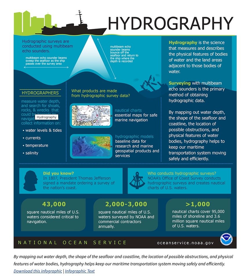
“I can tell you if you’re doing an amphibious operation, you want to understand what’s waiting beneath the surface in the water column,” Niedziocha noted. “So something can go either with a side-looking sonar array or even forward-looking to demonstrate that there’s nothing there, and the hydrography and bathymetry is what you… need for the operation to be successful.”

Hydrography measures “the shape and features of the shoreline; the characteristics of tides, currents, and waves; and the physical and chemical properties of the water itself,” according to NOAA. Bathymetry, which is part of that, focuses on mapping the depths and shapes of underwater terrain.

NOAA

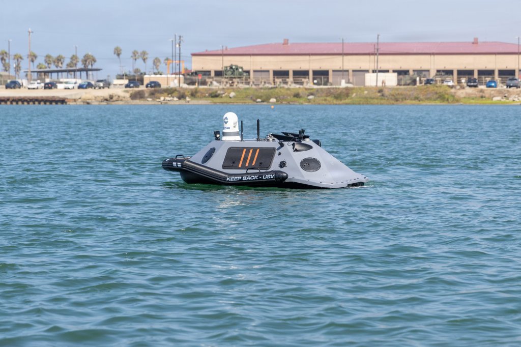
These functions are critical for mine detection and determining whether there are man-made or natural obstacles that would impede landing operations. While these missions are largely being performed by the Navy, including with USVs, the Marines are moving toward making that an organic capability. Recently, the Marines announced they were testing a counter-mine USV system. The evaluation was conducted late last month at Camp Pendleton by the Program Manager Combat Support Systems (PM CSS) Explosive Hazard Defeat Team.

The test of the USV was “in response to a littoral capability gap,” according to the media release. “The solution: seek a commercial USV solution that is equipped with integrated autonomous driving and payloads that consist of Sonar, Forward-Looking Infrared (FLIR) cameras, Line of Sight (LOS) Communications and Acoustic Communications (AComms).”

This was part of the overall effort to develop “solutions that enable increased standoff for Marines to detect, investigate and neutralize threats,” the release added. “The innovation of Explosive Ordnance Disposal (EOD) and Littoral Explosive Ordnance Neutralization (LEON) systems will provide Marine EOD Technicians with the confidence to operate in contested environments while preserving combat power, increasing operational reach, and minimizing exposure to explosive threats.”

LEON is a so-called system of systems, using a remotely operated vehicle, diver equipment, an unmanned underwater vehicle (UUV), a USV, and an Amphibious Unmanned Ground Vehicle to enable “EOD to confirm and mark hazards and obstacles from very shallow water to the beach zone,” the media release added.

While unmanned systems have long been part of EOD operations, “we’re expanding that into maritime systems that allow more endurance and less risk for operators,” said Chief Warrant Officer 2 Alfredo Andrade, officer in charge, Explosive Ordnance Disposal Company, 7th Engineer Support Battalion (ESB). “Some of the conflicts that we are engaged in take a toll on the force, and surging in new forces is costly. It turns into a logistical problem. To preserve the safety and the health of the forces… the USV and the [LEON] program exist to ensure that we have readily available combat power.”

In late August at Camp Pendleton, the PM CSS Explosive Hazard Defeat Team tested an Unmanned Surface Vessel in response to a littoral capability gap. The solution: seek a commercial USV solution that is equipped with integrated autonomous driving and payloads that consist of Sonar, Forward-Looking Infrared (FLIR) cameras, Line of Sight (LOS) Communications and Acoustic Communications (AComms). The LEON System of Systems (SOS) consists of five increments of capabilities to include a Remotely Operated Vehicle, diver equipment, Unmanned Underwater Vehicle, Unmanned Surface Vehicle, and an Amphibious Unmanned Ground Vehicle. LEON enables EOD to confirm and mark hazards and obstacles from very shallow water to the beach zone. (PAE Marine Corps photo by Kristiana Gehly)
In late August at Camp Pendleton, the PM CSS Explosive Hazard Defeat Team tested an unmanned surface vessel in response to a littoral capability gap. (PAE Marine Corps photo by Kristiana Gehly) Kristiana Gehly

While Niedziocha didn’t address USVs for offensive combat roles, the Marines have evaluated them for that use as well as for logistics, among other functions.

Our Autonomous Low-Profile Vessel (ALPV) solicitation is now accepting submissions.

The @DeptofWar and the @USMC need to resupply units spread over wide distances in contested littoral environments. Increased all-domain threats targeting logistics capabilities, locations, and… pic.twitter.com/Af8v0DTRHS

— Department of War Innovation Unit (@DIU_x) March 3, 2026

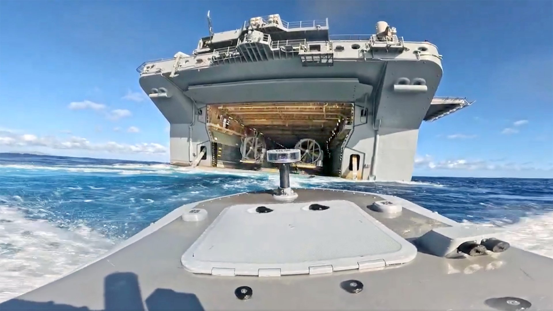
There have been many other tests, as well. Including one just this summer at RIMPAC. These trials saw the launch and recovery of one of Splash Industries’ Typhoon USVs aboard the USS Essex. The ‘Gator Navy’ of amphibious assault vessels that haul Marines and their kit around the oceans is uniquely suited to act as USV motherships. Their well decks allow for easy deployment and recovery of USVs of many sizes and capabilities near seamlessly. So it won’t be surprising if these vessels and the Marines aboard them quickly become staples in the Pentagon’s USV playbook.

Watch us land one of our drone-boats inside a moving US Navy warship during RIMPAC. This world-first resupply mission was performed completely autonomously using a Splash Industries Typhoon USV. pic.twitter.com/AEzNzZjsL1

— Ivan Avanesov (@i_vanesov) July 14, 2026

Still, the Marines have a long way to go to catch up to how these systems are already being used.

The Houthi rebels of Yemen actually pioneered the operational use of kamikaze USVs years ago and Ukraine has led the way in advancements of these systems. They first employed them as kamikaze weapons, but then added machine guns and rockets and later missiles, which were used to shoot down Russian helicopters and jets. Ukraine has also used them to launch first-person view (FPV) and bomber drone attacks as well as deliver uncrewed ground vehicles (UGVs) into enemy territory. Last week, Ukraine claimed to have attacked a Russian USV with a USV, marking another first.

You can see that engagement in the following video.

Ukraine's Navy says a Sargan unmanned surface vessel destroyed a Russian unmanned boat with machine-gun fire in the Black Sea, the first-ever battle between unmanned surface vessels. Ukrainian Navy personnel operated in coordination with HUR. #Ukraine pic.twitter.com/Avg4ecz8m6

— NOELREPORTS 🇪🇺 🇺🇦 (@NOELreports) September 12, 2026

Having recently returned from a six-month deployment that saw the Marine Corps’ first use of its Expeditionary Advanced Base Operations (EABO) concept in a combat setting during the fight against Iran, Niedziocha has a good sense of the realities of modern warfare. His Marines operated forward arming and refueling points (FARPs) for various aircraft in combat for the first time and set up remote sensing locations.

That a commander like him sees value in USVs is a good sign for progress in the development of these systems.

Contact the author: howard@twz.com

The post Marine Colonel Who Led Mideast Combat Deployment Wants His Own Drone Boats appeared first on TWZ.

  •  

🔴TUTTI A SECCO | TG 18.9.26

– Arabia Saudita, il re del greggio compra gasolio di Margherita Furlan
– Arabia Saudita, colpito un jet italiano di Jeff Hoffman
– Caccia italiani sul Baltico, retorica bellicista di Jeff Hoffman
– USA, riserva strategica ai minimi di Jeff Hoffman
– Meloni guarda a Oslo per l’energia di Ivan Bodyan
– Kuwait, l’ultimo tabù del Golfo di Jeff Hoffman
– Netanyahu vuole punire chi critica l’esercito di Ivan Bodyan
– Libano senza ONU, Parigi prende il posto di Jeff Hoffman
– Israele in Africa, il Marocco apre la porta di Jeff Hoffman
– L’UE punta il dito contro il Marocco di Gionata Chatillard
– Trump si prepara ad accogliere Xi Jinping di Ivan Bodyan
– Russia, elezioni per la Duma e a livello locale di Ivan Bodyan
– Buon giro intorno al Sole

A cura di Margherita Furlan Con la collaborazione di Gionata Chatillard, Ivan Bodyan e Jeff Hoffman Editing di Mario Ferdinandi

📡 CASA DEL SOLE TV — Informazione libera e indipendente Il nostro lavoro è possibile solo grazie al vostro sostegno. Casa del Sole TV non ha editori forti né finanziamenti pubblici: siamo sostenuti da voi, il nostro pubblico. Se credi nel valore di un’informazione che non tace, aiutaci a continuare.

💳 Dona tramite bonifico bancario: IBAN: IT63P0326822300052392596590 Intestato a: LA CASA DEL SOLE EDIZIONI Causale: Donazione Casa del Sole TV

🅿 Dona tramite PayPal: paypal.me/casadelsoletv

⏰Sostegno ricorrente: casadelsole.tv/sostienici

Anche un piccolo contributo fa la differenza.

Grazie di cuore! ❤

L'articolo 🔴TUTTI A SECCO | TG 18.9.26 proviene da Casa del Sole TV.

  •  

Odemira celebra os sabores do mar em nova Semana Gastronómica

O concelho de Odemira volta a celebrar a gastronomia local com uma nova edição da Semana Gastronómica do Peixe e do Marisco, que decorre entre 21 e 27 de setembro.

Promovida pelo Município de Odemira, a iniciativa reúne 10 restaurantes de diferentes localidades do concelho, que durante uma semana apresentam aos visitantes e à população diversas propostas gastronómicas inspiradas nos sabores do mar.

Entre as sugestões disponíveis encontram-se pratos como cataplanas, arroz de marisco, peixe grelhado, amêijoas à Bulhão Pato, massadas de peixe e açorda de gambas, a par de produtos como ostras, lagosta e lavagante.

A diversidade das propostas passa pelas receitas mais tradicionais da gastronomia local, mas também por interpretações e formas mais criativas de confecionar e apresentar os produtos do mar.

A Semana Gastronómica pretende valorizar os produtos do mar, promover a gastronomia local e dar a conhecer o trabalho desenvolvido pelos restaurantes do concelho, numa iniciativa que procura também reforçar a ligação entre a identidade gastronómica de Odemira e os seus recursos naturais.

Nesta edição participam A Barca Tranquitanas, a Marisqueira Sol Dourado e o Costa Alentejana, em Zambujeira do Mar; a Tasca do Celso e a Casa de Amigos do Benfica, em Vila Nova de Milfontes; o Bar da Praia, em Almograve; o João da Longueira e O Josué, em Longueira; O Peixeiro, em Amoreiras-Gare; e A Taberna Fonte Férrea, em Odemira.

Durante sete dias, residentes e visitantes são convidados a percorrer o concelho através dos seus sabores, descobrindo diferentes formas de preparar peixe e marisco e conhecendo a oferta gastronómica dos restaurantes aderentes.

A Semana Gastronómica do Peixe e do Marisco decorre de 21 a 27 de setembro, em vários restaurantes do concelho de Odemira.

  •  

ARTURb regressa a Lagos para a 15.ª edição com arte no espaço público

Entre 18 de setembro e 2 de outubro, Lagos volta a receber o ARTURb, projeto promovido pelo LAC – Laboratório de Actividades Criativas, que celebra este ano a sua 15.ª edição.

Durante duas semanas, cinco artistas nacionais e internacionais estarão em residência artística em Lagos, onde irão desenvolver novos trabalhos e intervir em diferentes espaços públicos da cidade. A iniciativa pretende aproximar a criação artística da comunidade e transformar o espaço urbano num lugar de expressão, encontro e reflexão.

Um dos momentos de destaque desta edição será a criação de um mural da artista Kruella D’Enfer, no Bairro 25 de Abril, na Meia Praia. A intervenção está prevista para decorrer entre 21 e 26 de setembro, levando a arte urbana para mais um espaço da cidade.

O ARTURb tem vindo, ao longo das suas várias edições, a promover a criação contemporânea e a intervenção artística no espaço público, proporcionando aos artistas condições para desenvolverem novos projetos e estabelecendo uma relação direta entre arte, território e comunidade.

A edição de 2026 culmina no dia 3 de outubro, às 18h00, no LAC, com a apresentação dos trabalhos desenvolvidos pelos artistas durante as residências.

O programa de encerramento inclui ainda uma conferência de Miguel Januário (± maismenos ±), artista conhecido pelo seu trabalho multidisciplinar e pela reflexão sobre questões sociais e políticas através da arte, e um DJ set, encerrando duas semanas dedicadas à criação artística contemporânea em Lagos.

A 15.ª edição do ARTURb reforça, assim, a aposta do LAC na dinamização cultural e artística de Lagos, promovendo o contacto entre artistas, comunidade e espaço público.

  •  

Texas Democrat James ‘God Is Non-Binary’ Talarico Pushes WEF-Approved Bible That Removes ‘Son of God’ Because It’s ‘Sexist’

Texas Democratic Senate candidate James Talarico’s sacrilegious church gives members copies of the “Inclusive Bible” — a modern WEF-approved translation designed to remove what its creators describe as “sexist” language and “stupid stuff,” according to [...]

The post Texas Democrat James ‘God Is Non-Binary’ Talarico Pushes WEF-Approved Bible That Removes ‘Son of God’ Because It’s ‘Sexist’ appeared first on The People's Voice.

  •  

Nova Associação de Jovens do Algoz apresenta-se à comunidade

A AJA – Associação de Jovens do Algoz vai apresentar-se publicamente à comunidade no próximo sábado, 19 de setembro, numa iniciativa que terá lugar no Largo da Junta de Freguesia de Algoz, a partir das 19h00.

Para assinalar o nascimento da nova associação, foi preparada uma festa de apresentação aberta a toda a comunidade, que contará com um baile animado por Roberto Bernardino, bem como com uma atuação do Rancho Folclórico do Algoz. Ao longo da noite não faltarão também momentos de animação e entretenimento, acompanhados de comes e bebes.

Criada por jovens do Algoz, a AJA assume-se como uma associação dirigida não apenas à população jovem, mas a toda a comunidade. O objetivo passa por desenvolver iniciativas em diferentes áreas, nomeadamente cultura, desporto e pedagogia, recorrendo a diferentes formas de participação e envolvimento.

“Uma associação nova, criada por jovens não só para jovens, mas também para toda a comunidade”, é assim que os responsáveis apresentam o projeto, destacando a vontade de dinamizar a localidade e criar novas oportunidades de participação.

“O nosso objetivo é simples, construir uma comunidade mais unida, como em tempos foi, e tornar o Algoz num lugar onde os jovens gostem de estar, de participar, de aprender e onde, acima de tudo, se sintam acolhidos”, afirma a AJA.

A associação deixa o convite a todos os jovens que queiram conhecer o projeto e participar nas suas atividades, mas também a todas as pessoas que, independentemente da idade, mantenham “espírito jovem, vontade de participar e, sobretudo, vontade de ver o Algoz crescer e evoluir”.

Desde a sua criação, a AJA tem contado com o apoio e a parceria de várias entidades locais, entre as quais a Câmara Municipal de Silves, a Junta de Freguesia de Algoz, a Junta de Freguesia de Armação de Pêra, a Junta de Freguesia de Alcantarilha e a Junta de Freguesia da Guia.

O projeto conta igualmente com o apoio de empresas e estabelecimentos locais, nomeadamente a Agência de Viagens e Turismo Asalgarve, Intermarché Algoz, Supermercados Coviran – Henrique & Henriques, Lda., Purplemystery, Lda., Café Rodrigues, Talhos Santos, Papelaria T&B, Tasca Senhora do Pilar, Café Tabuense, Restaurante Sobretempero, Mercearia – Snack-Bar Marreiros, JB Firewood – Comércio de Lenha e Derivados e Bar Dois Irmãos.

Com a criação da AJA, os seus responsáveis pretendem reforçar a participação dos jovens na vida da comunidade e contribuir para a dinamização do Algoz, através da promoção de atividades de convívio, aprendizagem, desporto, cultura e lazer.

A apresentação pública da AJA – Associação de Jovens do Algoz acontece no sábado, 19 de setembro, a partir das 19h00, no Largo da Junta de Freguesia de Algoz. A entrada é livre e aberta a toda a comunidade.

  •  

Cumbre del BRICS+: entre promesas y contradicciones

Read in English here

La 18va Cumbre del BRICS, celebrada en Nueva Delhi del 12 al 13 de septiembre, tuvo lugar en medio de una intensificación excepcional de las contradicciones internacionales. Las guerras en Asia Occidental, las sanciones unilaterales, las barreras arancelarias y el uso de las finanzas y la tecnología como armas han puesto de manifiesto el carácter fundamentalmente desigual del orden internacional dominado por el imperialismo. En este contexto, la continua expansión del BRICS refleja el deseo de los países en desarrollo de alcanzar una mayor autonomía estratégica y un sistema más democrático de gobernanza global. Al mismo tiempo, la cumbre demostró que el BRICS+ sigue siendo una agrupación heterogénea cuyos miembros difieren sustancialmente en sus alineamientos políticos e intereses económicos.

La Declaración de Nueva Delhi, resultado de la cumbre, reiteró la exigencia de una reforma de las Naciones Unidas, las instituciones financieras internacionales y el sistema comercial multilateral. Se opuso a las sanciones unilaterales no autorizadas por el Consejo de Seguridad de las Naciones Unidas y abogó por un mayor comercio en monedas nacionales. La declaración también respaldó una mayor representación de los países en desarrollo en instituciones cuyas normas siguen siendo determinadas principalmente por los Estados Unidos y sus aliados. Estas posturas tienen una importancia objetiva en un momento en que Washington recurre cada vez más a sanciones, aranceles, controles a la exportación y control sobre los sistemas de pago para disciplinar a los países que se niegan a aceptar sus dictados.

Ambigüedad

Sin embargo, el lenguaje cuidadosamente negociado de la declaración también reveló las limitaciones de la formación ampliada. El BRICS+ incluye ahora a países sometidos a una presión occidental sostenida, como Rusia e Irán, así como a los Emiratos Árabes Unidos y otros Estados que mantienen amplios vínculos económicos y de seguridad con Occidente. En consecuencia, el consenso solo puede mantenerse mediante formulaciones que reconozcan los conflictos sin identificar siempre sus causas políticas. Esta ambigüedad fue especialmente evidente en el tratamiento que se dio en la cumbre a la guerra cada vez más extensa en Asia Occidental y a la postura adoptada por Irán.

El presidente iraní, Masoud Pezeshkian, aprovechó la cumbre para denunciar las sanciones unilaterales y la guerra de agresión contra Irán llevada a cabo por los Estados Unidos e Israel. Destacó acertadamente que la resiliencia económica no puede separarse de la paz, la soberanía y la seguridad. Irán también abogó por el comercio en monedas nacionales, un mayor uso del Nuevo Banco de Desarrollo y la construcción de corredores independientes de transporte y energía (tal como ya lo ha hecho a través de Pakistán, que ha proporcionado seis rutas terrestres para que las mercancías chinas y rusas ingresen a Irán). Para un país sometido a décadas de sanciones, a la exclusión de las redes financieras occidentales y a repetidas amenazas de cambio de régimen, la pertenencia al BRICS+ representa una importante oportunidad diplomática y económica.

La postura de Irán, sin embargo, presenta una marcada ambigüedad. Teherán presenta al BRICS+ como un instrumento para resistir el unilateralismo y defender la soberanía. Al mismo tiempo, debe buscar un acuerdo con los estados vecinos del Golfo, varios de los cuales están profundamente integrados con el capital occidental y los acuerdos de seguridad.

Irán firmó una declaración en la que se pedía moderación y desescalada, al tiempo que acusaba a los Estados Unidos e Israel de agresión y defendía sus propias acciones de represalia. Su postura combativa frente a la presión hiperimperialista se combina, por lo tanto, con un esfuerzo pragmático por evitar el aislamiento regional, asegurar el alivio de las sanciones y preservar los canales de negociación.

Esto no debe interpretarse simplemente como una inconsistencia. Irán se enfrenta a una coalición militar y financiera muy superior y debe maniobrar dentro de severas limitaciones. Pero también ilustra el problema más amplio al que se enfrenta el BRICS+. La oposición a la dominación occidental no genera automáticamente un programa antiimperialista coherente. Los Estados participantes son Estados capitalistas que persiguen sus respectivos intereses nacionales. Sus clases dominantes pueden resistirse a aspectos particulares de la hegemonía estadounidense, al tiempo que se mantienen dispuestas a llegar a acuerdos con las finanzas globales o con potencias reaccionarias regionales. En consecuencia, el BRICS+ es un escenario de lucha dentro del orden mundial en transformación, no una alternativa ya constituida al hiperimperialismo.

Socios

El acontecimiento político más trascendental de la cumbre para Asia fue la reunión entre el primer ministro Narendra Modi y el presidente chino Xi Jinping. La primera visita de Xi a la India en siete años confirmó la mejora gradual de las relaciones desde los acuerdos de retirada militar iniciados en 2024. Los dos líderes coincidieron en que la India y China deben considerarse socios en lugar de rivales y abordar las relaciones bilaterales desde una perspectiva estratégica a largo plazo. También discutieron la cuestión fronteriza, el comercio, el acceso a los mercados y los problemas de la cadena de suministro.

Cualquier mejora duradera en las relaciones entre la India y China debe ser bienvenida. La prolongada confrontación tras el enfrentamiento en el valle de Galwan de 2020 perjudicó a ambos países, aumentó el gasto militar y fortaleció los esfuerzos de los Estados Unidos por incorporar a la India a su estrategia indopacífica. Washington ha buscado constantemente convertir a la India en un contrapeso estratégico frente a China a través del Quad y la expansión de la cooperación militar y tecnológica. Por lo tanto, una confrontación continua entre la India y China beneficia mucho más a la estrategia de los Estados Unidos que a los intereses de los pueblos indio o chino.

La paz y la tranquilidad a lo largo de la Línea de Control Efectivo siguen siendo indispensables. Los acuerdos sobre la retirada deben ir seguidos de un compromiso sostenido a nivel diplomático y militar, la aclaración de las zonas en disputa y la observancia estricta de los acuerdos existentes. No se debe permitir que ni la retórica nacionalista ni la construcción competitiva de infraestructura desencadenen otra confrontación. Las diferencias sobre la frontera no pueden ignorarse, pero pueden y deben gestionarse sin subordinar toda la relación a una rivalidad militarizada.

Las relaciones económicas presentan una contradicción igualmente difícil. China es uno de los mayores socios comerciales de la India y una importante fuente de maquinaria, componentes electrónicos, productos químicos, equipos de energía renovable y otros insumos industriales. Sin embargo, el enorme déficit comercial de la India con China refleja tanto la debilidad del sector manufacturero indio como los obstáculos que enfrentan las exportaciones indias en el mercado chino. Para abordar este desequilibrio se requiere un mejor acceso al mercado, inversión china en condiciones transparentes y, sobre todo, una política industrial india capaz de desarrollar la capacidad productiva nacional. Durante los últimos seis meses, el comercio bilateral se ha disparado.

El enfoque del Gobierno de Modi ha alternado entre la dependencia de las importaciones chinas y las restricciones, motivadas políticamente, a la inversión y la tecnología chinas. Su retórica de “China más uno” no puede ocultar el fracaso de sus propias políticas para generar una industrialización de base amplia. Tampoco una alineación estratégica más estrecha con los Estados Unidos puede proporcionar a la India una base manufacturera independiente. Los Estados Unidos busca un acceso privilegiado al mercado indio, al tiempo que recurre a aranceles, restricciones tecnológicas y presión política cada vez que las políticas indias se apartan de sus intereses. La incoherencia del Gobierno de Modi se pone de manifiesto, sobre todo, en su incapacidad para elaborar realmente una agenda nacional de desarrollo que aproveche el dinamismo de la economía china y se distancie de unos Estados Unidos más orientados hacia el nacionalismo económico.

China, por su parte, debe reconocer que unas relaciones estables requieren sensibilidad ante las preocupaciones legítimas de la India. Entre ellas se encuentran la cuestión fronteriza sin resolver, el acceso desigual al mercado y el desequilibrio comercial. La considerable asimetría entre las dos economías hace que la reciprocidad sea particularmente importante. El llamado de Pekín a la colaboración solo cobrará sentido cuando vaya acompañado de medidas prácticas que permitan el ingreso de bienes y servicios indios al mercado chino y eviten que las tensiones fronterizas acaben repetidamente por opacar el diálogo político.

La cooperación entre la India y China otorgaría al BRICS+ un peso mucho mayor en la lucha por la democratización del orden internacional. Juntos, ambos países representan más de un tercio de la humanidad.

Su cooperación podría impulsar la reforma de las instituciones internacionales, el financiamiento climático, el intercambio de tecnología, las iniciativas de salud pública y un sistema comercial más justo. Por el contrario, una nueva confrontación paralizaría al BRICS+ y permitiría que potencias externas se aprovecharan de las divisiones en toda Asia. Por lo tanto, la India debe seguir una política exterior independiente basada en la coexistencia pacífica, y no participar en un proyecto estadounidense destinado a contener a China.

La cumbre de Nueva Delhi generó propuestas para la continuidad institucional, una cooperación financiera más sólida y una mayor resiliencia entre las economías en desarrollo. Sin embargo, las declaraciones tendrán un valor limitado a menos que se traduzcan en acuerdos concretos. El Nuevo Banco de Desarrollo debe ampliar los préstamos en monedas nacionales y dar prioridad a la infraestructura socialmente necesaria, en lugar de reproducir las condiciones y la orientación corporativa del Banco Mundial. Los mecanismos de pago transfronterizos deben desarrollarse de manera transparente, sin crear nuevas formas de dominación por parte de las economías más fuertes del BRICS. Las enérgicas declaraciones en apoyo de la Revolución Cubana y de las aspiraciones de autodeterminación del pueblo palestino deberán tener una aplicación práctica. ¿Encontrará el BRICS+ una manera de romper el cruel e ilegal embargo de Estados Unidos contra Cuba, y brindará el BRICS+ apoyo para la reactivación de la vida política palestina?

El BRICS+ encarna tanto el movimiento hacia un nuevo equilibrio mundial como todas las contradicciones de ese movimiento. El cauteloso acercamiento entre India y China es un ejemplo de dicha contradicción, ya que combina el reconocimiento de la dependencia mutua con una desconfianza estratégica sin resolver. El futuro del BRICS+ dependerá de si dichas contradicciones se gestionan de manera pacífica y de si la cooperación genera beneficios tangibles para los trabajadores, en lugar de limitarse a ampliar el margen de maniobra de las clases dominantes nacionales.

Para la India, el camino a seguir es claro: restablecer relaciones normales y pacíficas con China, resistirse a ser incorporada a la estrategia militar de los Estados Unidos, oponerse a la agresión y a las sanciones unilaterales contra Irán, y trabajar por un orden multilateral genuinamente democrático. Solo habrá un nuevo equilibrio mundial cuando se restrinja la dominación hiperimperialista y se amplíen la soberanía y las posibilidades de desarrollo de los pueblos. La cumbre de Nueva Delhi marcó un paso más en esa transición controvertida, pero la dirección y el contenido social del orden emergente siguen siendo objeto de lucha política.

Vijay Prashad es un historiador y periodista indio. Es autor de cuarenta libros, entre los que se incluyen Balas de Washington, Una estrella roja sobre el Tercer Mundo, Las naciones oscuras: una historia del Tercer Mundo; Las naciones pobres: una posible historia del Sur Global y How the International Monetary Fund Suffocates Africa, escrito con Grieve Chelwa. Es el director ejecutivo de Tricontinental: Instituto de Investigación Social, corresponsal jefe de Globetrotter, y el editor jefe de LeftWord Books (Nueva Delhi). También ha hecho apariciones en las películas Shadow World (2016) y Two Meetings (2017).

Este artículo fue elaborado por Globetrotter.

  •  
❌